State Highway · Nassau & Suffolk County

Sunrise Highway Traffic & Accidents

Real-time accident reports, live traffic conditions, and the most comprehensive safety guide to Sunrise Highway (NY-27), Long Island's main South Shore arterial from Valley Stream to Montauk. Updated every 4 hours.

Recent incidents 1 accident in the last 24 hours · as of Jun 30 View live incidents →
Tracked incidents
49
Length
100 mi
Speed limit
55 mph (limited-access sections); 40–45 mph (signalized commercial corridors)
Daily traffic
80k

Route Overview

From
Valley Stream (Nassau County)
To
Montauk Point (Suffolk County)
Also Known As
Sunrise Hwy, Route 27, NY-27, NY 27, State Route 27, Sunrise, state-route-27, ny-route-27, route-27

Why the Sunrise Highway Matters

Congestion & Risk

One of Long Island's highest-volume surface arterials and the principal South Shore truck route; its Nassau and western-Suffolk commercial corridors are repeatedly flagged in NYSDOT crash analyses for elevated pedestrian and rear-end crash rates.

History

Developed from early-20th-century South Shore local roads into a numbered state route in the 1920s–1930s. The Nassau County section was progressively rebuilt as a divided, partially grade-separated arterial through the mid-20th century as South Shore suburbanization accelerated; the East End sections remain a conventional two-lane road.

About Sunrise Highway

Sunrise Highway — designated New York State Route 27 and known to most Long Islanders simply as “Sunrise” — is the principal arterial of Long Island’s South Shore. Stretching roughly 100 miles from Valley Stream near the Queens border in Nassau County east to Montauk Point at the far tip of the South Fork, it is the South Shore’s workhorse road: commuter route, commercial corridor, and the main truck artery for the towns that the parkways refuse to carry. Where the parallel Southern State Parkway to the north bans commercial traffic and threads through low stone overpasses, Sunrise Highway is a conventional state road open to everything — and that openness shapes both its usefulness and its crash profile.

What makes Sunrise Highway distinctive is that it is really three roads wearing one name. Through Nassau County it behaves like an expressway: a divided, partially grade-separated highway with numbered exits and a 55 mph design speed. Through western and central Suffolk it becomes a signalized commercial arterial lined with retail. And on the East End, past the Shinnecock Canal, it narrows toward a two-lane village road on its way to Montauk. A driver crossing the full corridor experiences three completely different driving environments, and the transitions between them are where many of its problems concentrate.

Origins and construction

Sunrise Highway grew out of a patchwork of early-20th-century South Shore local roads that were stitched together and numbered as a state route in the 1920s and 1930s. As post-war suburbanization filled in Nassau County’s South Shore, the Nassau section was progressively rebuilt into a divided, partially grade-separated arterial — giving it a quasi-expressway character for roughly 20 miles. The eastern reaches were never rebuilt to the same standard; the East End sections remain a conventional surface road, reflecting the lighter development of the South Fork. The result is a corridor whose engineering standard drops, step by step, the farther east you drive.

Route geometry (Valley Stream → Montauk)

From west to east, Sunrise Highway begins in Valley Stream near the Nassau–Queens line and runs through the dense Nassau commercial belt of Lynbrook, Rockville Centre, Baldwin, Freeport, Merrick, Bellmore, and Massapequa. Crossing into Suffolk County, it passes through Amityville, Copiague, Lindenhurst, and Babylon, then on through Bay Shore, Islip, Sayville, and Patchogue. Continuing east it serves Bellport, Brookhaven, Shirley, and the Moriches before reaching the East End, where it carries on through Hampton Bays, Southampton, East Hampton, and Amagansett to its terminus at Montauk. The corridor intersects nearly every major South Shore route, including the Meadowbrook, Wantagh, and Robert Moses parkways, the Southern State Parkway, the Seaford–Oyster Bay Expressway (Route 135), Veterans Memorial Highway, and Nicolls Road (CR 97) in central Suffolk.

Jurisdiction and patrol

Because Sunrise Highway is a surface highway rather than a state-police-patrolled parkway, jurisdiction follows the county and town it runs through. The Nassau County Police Department patrols the Nassau divided-highway section. The Suffolk County Police Department covers the western and central Suffolk segments through its precinct system. On the East End — Southampton and East Hampton towns, which run their own departments — the Southampton Town Police and East Hampton Town Police are the primary responding agencies, as seen in the reporting on the fatal Southampton crash below. NYS Police Troop L assists on the limited-access segments and at major multi-vehicle incidents. The roadway itself is owned and maintained by NYSDOT.

Speed limits

Posted limits change repeatedly along the corridor, tracking its shifting character. The divided, limited-access stretches in Nassau and parts of western Suffolk are posted at 55 mph. The signalized commercial corridors through Valley Stream, Freeport, Babylon, and Bay Shore drop to 40–45 mph. The two-lane East End sections run 40–55 mph depending on village limits. Drivers unfamiliar with the road frequently carry expressway speeds into the slower arterial sections — a recurring factor in rear-end and pedestrian crashes.

Trucks and commercial vehicles

Sunrise Highway is the South Shore’s primary truck route, and this is its single most important operational distinction. The parkways that parallel it — the Southern State, Wantagh, Meadowbrook, and Robert Moses — all ban commercial vehicles and were built with low clearances that physically exclude trucks. That leaves Sunrise Highway (NY-27) as the only continuous South Shore route legal for trucks and buses. The corridor therefore carries a heavier commercial-vehicle mix than the parkways, which raises both crash severity and the frequency of debris and disabled-vehicle events — a dynamic visible in the fatal garbage-truck rollover and the tow-truck-operator fatality documented below.

Dangerous Sections

The following segments are recurring crash and closure locations based on NYSDOT crash patterns and Long Island Traffic’s running corpus of Sunrise Highway incident reports.

Valley Stream / Lynbrook (Nassau County western section): The western end of Sunrise Highway handles enormous commercial traffic generated by the Green Acres Mall and the dense retail strip running east toward Lynbrook and Rockville Centre. Frequent driveway cuts, pedestrian crossings, and turning movements at signalized intersections collide with high-speed through traffic. This is one of the corridor’s highest pedestrian-injury zones.

Freeport commercial corridor: The Freeport stretch carries one of the highest pedestrian crash rates on the entire road. Long stretches between protected crossings, combined with dense retail on both sides and near-highway speeds, produce a persistent pedestrian-safety problem that Nassau County and NYSDOT have repeatedly studied for traffic-calming improvements.

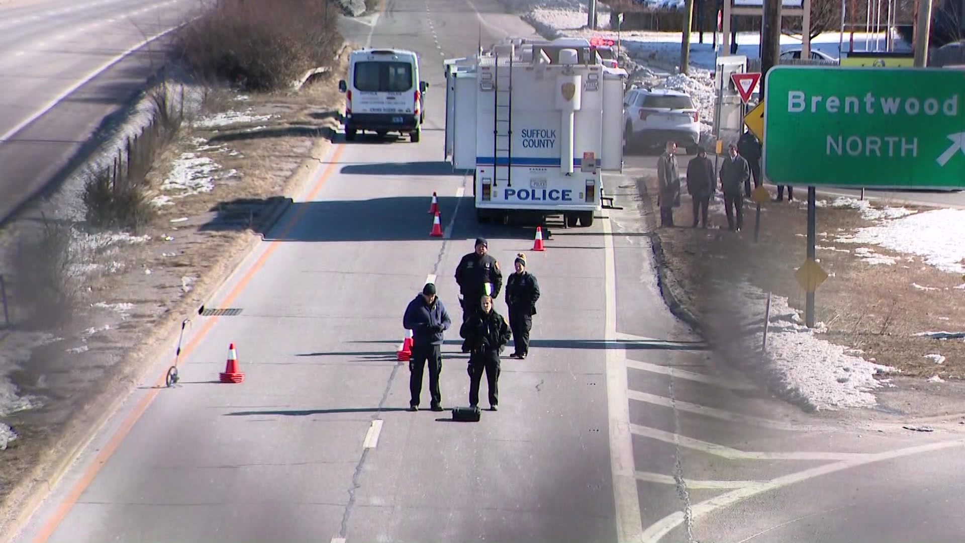
Bay Shore — Exit 44 area (Suffolk County): The approaches to Bay Shore near Exit 44 and Brentwood Road are a documented hot spot, with heavy commercial-truck traffic and a narrow, high-speed shoulder environment. In April 2025 a tow-truck operator working the shoulder near Exit 44 was struck and killed there — see the editorial coverage below. The interchange weaving and roadside-work exposure make this one of the corridor’s most dangerous Suffolk segments.

Central Suffolk — Exits 53 to 56 (Patchogue to North Bellport): The central-Suffolk stretch from around Exit 53 through Exit 56 in North Bellport sees frequent serious crashes and full closures, including a pedestrian-involved closure at Exit 53 and a multi-hour westbound shutdown at Exit 56 near Station Road. Early-morning commute crashes here routinely close lanes for investigation, snarling westbound traffic toward New York City.

East End two-lane sections (Hampton Bays to Montauk): East of the Shinnecock Canal, Sunrise/Montauk Highway narrows to two lanes through Southampton and East Hampton. High summer beach volumes, limited passing opportunities, and dark rural stretches at night produce severe head-on and multi-vehicle collisions — including the fatal five-vehicle Southampton crash detailed below.

Towns and Communities Along the Route

Sunrise Highway passes through or borders the following Long Island communities, listed roughly west-to-east:

Each town profile carries its own crash-frequency data, hospital and emergency-services list, and the recent accident archive filtered to that municipality.

Recent Editorial Coverage

Sunrise Highway crash reporting from the Long Island Traffic data desk:

For the complete Sunrise Highway accident archive, see /accidents/ and filter by road.

Accident Statistics

Sunrise Highway’s crash profile reflects its split personality as both a quasi-expressway and a commercial arterial. Across its Nassau and Suffolk segments the corridor records on the order of several thousand reported crashes annually, with the Nassau County commercial section accounting for a disproportionate share of injury and pedestrian crashes because of its dense, signalized, driveway-heavy design. Rear-end collisions dominate the divided-highway sections where drivers carry expressway speeds into slowing traffic, while pedestrian and bicycle crashes are elevated relative to the parallel Southern State Parkway — a direct consequence of the road’s commercial land use and near-highway speeds. On the East End, the two-lane sections see a higher share of head-on and multi-vehicle crashes, particularly at night and during the summer beach season.

These figures are qualitative ranges drawn from NYSDOT crash patterns; precise annual counts vary year to year, and NYSDOT Motor Vehicle Crash data and NY Open Data are the authoritative sources for exact totals. For the most current picture of conditions on the road right now, the Live Accident & Traffic Reports section above pulls directly from 511NY and our own ingestion pipeline.

Drivers hurt on Sunrise Highway often have a claim worth more than the first insurance offer — a Long Island car accident attorney can review it for free.

Sunrise Highway Conditions Today — Live 719 active

Tuesday, June 30: 33 active accidents, 230 road-work zones, and 72 closures on Sunrise Highway right now — data from 511NY + police feeds, updated Jun 30, 8:32 PM.

72 high impact 204 moderate 59 low 83 EB · 86 WB work zones

Recent Sunrise Highway Incidents

Active Closures (72)

High impact Both Directions

on NY 27A

High impact Both Directions

on NY 27A

High impact Eastbound

accidentsAndIncidents on NY 27

All lanes closed
High impact Westbound

Exit 56 – Station Road

All lanes closed · ends 5:00 AM
High impact Westbound

Exit 56 – Station Road

All lanes closed
High impact Westbound

Exit 56 – Station Road

All lanes closed · ends 5:00 AM
High impact Westbound

Exit 56 – Station Road

All lanes closed · ends 5:00 AM
High impact Westbound

Exit 56 – Station Road

All lanes closed · ends 5:00 AM
High impact Westbound

Exit 56 – Station Road

All lanes closed · ends 5:00 AM
High impact Westbound

Exit 56 – Station Road

All lanes closed · ends 5:00 AM
High impact Eastbound

accidentsAndIncidents on NY 27

All lanes closed
High impact Westbound

Exit 56 – Station Road

All lanes closed · ends 5:00 AM
High impact Westbound

Exit 57 → 56: Horse Block Road – Station Road

High impact Both Directions

on NY 27

High impact Westbound

Exit 56 – Station Road

All lanes closed · ends 5:00 AM
High impact Eastbound

accidentsAndIncidents on NY 27

All lanes closed
High impact Westbound

Exit 56 – Station Road

All lanes closed · ends 5:00 AM
High impact Westbound

Exit 49 → 47: Lakeland Avenue – Pond Rd South

All lanes closed · ends 6:00 AM
High impact Westbound

Exit 56 – Station Road

All lanes closed · ends 5:00 AM
High impact Westbound

Exit 56 – Station Road

All lanes closed · ends 5:00 AM
High impact Westbound

Exit 56 – Station Road

All lanes closed · ends 5:00 AM
High impact Eastbound

SPEONK-RIVERHEAD RD

High impact Westbound

Exit 56 – Station Road

All lanes closed · ends 4:00 AM
High impact Westbound

Exit 49 → 47A: Lakeland Avenue – Oakdale Bohemia Road

All lanes closed · ends 6:00 AM
High impact Westbound

Exit 50 → 47: Lincoln Avenue – Pond Rd South

All lanes closed · ends 6:00 AM
High impact Westbound

Exit 56 – Station Road

All lanes closed · ends 5:00 AM
High impact Westbound

Exit 56 – Station Road

All lanes closed · ends 5:00 AM
High impact Westbound

Exit 56 – Station Road

All lanes closed · ends 5:00 AM
High impact Westbound

Exit 50A → 48: Johnson Avenue – Smithtown Avenue

All lanes closed · ends 6:00 AM
High impact Westbound

Exit 51 → 49: Veterans Memorial Highway – Lakeland Avenue

All lanes closed · ends 6:00 AM
High impact Westbound

Exit 56 – Station Road

All lanes closed · ends 5:00 AM
High impact Westbound

Exit 57 → 56: Horse Block Road – Station Road

High impact Eastbound

Monell Avenue

High impact Both Directions

on NY 27

High impact Westbound

on NY 27

All lanes closed · ends 6:00 AM
High impact Westbound

Exit 40 – NY 231

All lanes closed · ends 5:00 AM
High impact Westbound

Exit 51 → 50: Veterans Memorial Highway – Lincoln Avenue

All lanes closed · ends 6:00 AM
High impact Westbound

Exit 40 – NY 231

All lanes closed · ends 5:00 AM
High impact Westbound

Exit 51 – Veterans Memorial Highway

All lanes closed · ends 5:00 AM
High impact Westbound

Exit 40 – NY 231

All lanes closed · ends 5:00 AM
High impact Westbound

Exit 40 – NY 231

All lanes closed · ends 5:00 AM
High impact Eastbound

Exit 50 – Lincoln Avenue

All lanes closed · ends 6:00 AM
High impact Eastbound

Exit 47 – Pond Rd South

All lanes closed · ends 6:00 AM
High impact Both Directions

on NY 27A

High impact Westbound

Exit 41 → 40: Robert Moses Causeway – NY 231

High impact Eastbound

Exit 46A → 47A: NY27A – Oakdale Bohemia Road

High impact Eastbound

Exit 48 → 50: Smithtown Avenue – Lincoln Avenue

All lanes closed · ends 6:00 AM
High impact Westbound

Exit 40 – NY 231

All lanes closed · ends 5:00 AM
High impact Westbound

Exit 40 – NY 231

All lanes closed · ends 5:00 AM
High impact Westbound

Exit 40 – NY 231

All lanes closed
High impact Eastbound

Exit 47 → 48: Pond Rd South – Smithtown Avenue

All lanes closed · ends 6:00 AM
High impact Westbound

Exit 40 – NY 231

All lanes closed · ends 5:00 AM
High impact Eastbound

Exit 47 → 49: Pond Rd South – Lakeland Avenue

All lanes closed · ends 6:00 AM
High impact Westbound

Exit 56 – Station Road

All lanes closed
High impact Westbound

Exit 40 – NY 231

All lanes closed · ends 5:00 AM
High impact Eastbound

Exit 51 – Veterans Memorial Highway

All lanes closed
High impact Eastbound

on NY 27

All lanes closed · ends 5:00 AM
High impact Westbound

Exit 40 – NY 231

All lanes closed · ends 5:00 AM
High impact Westbound

Exit 40 – NY 231

All lanes closed · ends 5:00 AM
High impact Eastbound

Exit 49 → 50: Lakeland Avenue – Lincoln Avenue

All lanes closed · ends 6:00 AM
High impact Westbound

Exit 40 – NY 231

All lanes closed · ends 5:00 AM
High impact Eastbound

Exit 48 → 50A: Smithtown Avenue – Johnson Avenue

All lanes closed · ends 6:00 AM
High impact Westbound

Exit 40 – NY 231

All lanes closed · ends 5:00 AM
High impact Westbound

Exit 56 – Station Road

All lanes closed
High impact Westbound

Exit 40 – NY 231

All lanes closed · ends 5:00 AM
High impact Westbound

Exit 40 – NY 231

All lanes closed · ends 5:00 AM
High impact Westbound

Exit 40 – NY 231

All lanes closed
High impact Westbound

Exit 41 – Robert Moses Causeway

High impact Both Directions

on NY 27A

High impact Westbound

on NY 27

All lanes closed
High impact Both Directions

accidentsAndIncidents on NY 27A

All lanes closed
High impact Westbound

Exit 43 – 5th Avenue

All lanes closed

Active Road Work (230 zones)

Moderate impact Eastbound +50 nearby

on NY 27

1 Right lane closed · ends 3:00 PM
Moderate impact Westbound +47 nearby

Construction on NY 27

1 Right lane closed · ends 2:00 PM
Moderate impact Westbound +34 nearby

Exit 66 → 65: North Shore Highway – Hamptons Bay Road

1 Left lane closed · ends 3:00 PM
Moderate impact Eastbound +24 nearby

Construction on NY 27

1 Right lane closed · ends 3:00 PM
Moderate impact Westbound +16 nearby

on NY 27

1 Left lane closed · ends 3:00 PM
Moderate impact Westbound +16 nearby

Exit 65 – Hamptons Bay Road

1 Right lane closed · ends 2:00 PM
Moderate impact Eastbound +12 nearby

Exit 65 → 66: Hamptons Bay Road – North Shore Highway

1 Left lane closed · ends 3:00 PM
Moderate impact Both Directions +10 nearby

Construction on NY 27

· ends 3:00 PM
Moderate impact Both Directions +9 nearby

Exit 65 → 66: Hamptons Bay Road – North Shore Highway

1 Left lane closed · ends 5:00 AM
Moderate impact Both Directions +7 nearby

on NY 27

1 Left lane closed · ends 3:00 PM
Moderate impact Eastbound +6 nearby

Exit 65 – Hamptons Bay Road

1 Right lane closed · ends 2:00 PM
Moderate impact Westbound +6 nearby

East 7th Street

· ends 3:00 PM
Show 218 more work zones ↓
Moderate Westbound

7th Avenue

· ends 3:00 PM
Moderate Eastbound

Exit 5 – East 5th Street

1 Right lane closed · ends 3:00 PM
Moderate Westbound

Exit 4 – John P Devaney Boulevard

· ends 3:00 PM
Moderate Westbound

11th Avenue

· ends 6:00 AM
Moderate Eastbound

CATON AVENUE

1 Right lane closed · ends 3:00 PM
Moderate Westbound

Exit 40 – NY 231

1 Right lane closed · ends 3:00 PM
Moderate Westbound

Exit 66 – North Shore Highway

1 Right lane closed · ends 2:00 PM
Moderate Eastbound

Exit 66 – North Shore Highway

1 Right lane closed · ends 3:00 PM
Moderate Eastbound

Exit 50 – Lincoln Avenue

1 Left lane closed · ends 2:00 PM
Moderate Westbound

Pothole repair on NY 27

Moderate Eastbound

Exit 47 – Pond Rd South

1 Right lane closed · ends 6:00 AM
Moderate Eastbound

Morris Avenue

· ends 3:00 PM
Moderate Eastbound

6th Avenue

Moderate Westbound

I-678

· ends 2:00 PM
Moderate Both Directions

Exit 65 – Hamptons Bay Road

Moderate Eastbound

Exit 64 → 65: Lewis Road – Hamptons Bay Road

1 Left lane closed
Moderate Eastbound

Exit 52 – Waverly Avenue

1 Right lane closed · ends 3:00 PM
Moderate Westbound

8th Avenue

1 Right lane closed · ends 5:00 AM
Moderate Eastbound

Exit 49 → 50: Lakeland Avenue – Lincoln Avenue

2 Left lanes closed · ends 2:00 AM
Moderate Eastbound

Drainage improvements, Repaving, Roadwork on NY 27

Moderate Eastbound

Exit 4 – John P Devaney Boulevard

Moderate Westbound

Exit 49 → 47A: Lakeland Avenue – Oakdale Bohemia Road

1 Center lane closed · ends 5:00 AM
Moderate Both Directions

Utility work on NY 277

Moderate Eastbound

Mildred Place

1 Right lane closed · ends 4:00 AM
Moderate Eastbound

Utility work, Traffic signal repairs on NY 27

Moderate Both Directions

Exit 4 – John P Devaney Boulevard

Moderate Westbound

Mowing, Repaving, Roadwork on NY 27

Moderate Westbound

Exit 46 – Carleton Avenue

· ends 3:00 AM
Moderate Eastbound

Exit 49 – Lakeland Avenue

1 Right lane closed · ends 2:00 AM
Moderate Eastbound

Exit 48 → 49: Smithtown Avenue – Lakeland Avenue

· ends 3:00 AM
Moderate Eastbound

Exit 40 – NY 231

2 Right lanes closed · ends 5:00 AM
Moderate Eastbound

Exit 48 – Smithtown Avenue

1 Left lane closed · ends 3:00 PM
Moderate Westbound

Exit 64 – Lewis Road

1 Right lane closed
Moderate Westbound

Exit 51 – Veterans Memorial Highway

1 Left lane closed
Moderate Both Directions

Exit 37 → 38: Farmingdale Road – Little East Neck Road

Moderate Westbound

Exit 59 → 58: Wading River Road – William Floyd Parkway

Moderate Westbound

Exit 47 – Pond Rd South

1 Right lane closed · ends 6:00 AM
Moderate Westbound

Exit 47A → 47: Oakdale Bohemia Road – Pond Rd South

Moderate Westbound

Exit 63 → 62: Old Riverhead Road – West Hampton Road

1 Right lane closed · ends 3:00 PM
Moderate Eastbound

Exit 61 → 66: Moriches-Riverhead Road – North Shore Highway

1 Left lane closed
Moderate Both Directions

Exit 37 → 41: Farmingdale Road – Robert Moses Causeway

Moderate Westbound

Exit 44 – Brentwood Road

1 Left lane closed · ends 3:00 PM
Moderate Eastbound

Repaving on NY 27

Moderate Both Directions

Milling on NY 27

Moderate Eastbound

Centre Avenue

1 Right lane closed · ends 2:30 AM
Moderate Westbound

Exit 54 → 52: Hospital Road – Waverly Avenue

1 Left lane closed · ends 3:00 PM
Moderate Westbound

Exit 38 – Little East Neck Road

· ends 3:00 PM
Moderate Both Directions

Exit 64 → 65: Lewis Road – Hamptons Bay Road

Moderate Both Directions

Exit 5 – East 5th Street

Moderate Westbound

Exit 65 → 64: Hamptons Bay Road – Lewis Road

Moderate Westbound

Exit 49 – Lakeland Avenue

2 Right lanes closed · ends 4:00 AM
Moderate Both Directions

on NY 277

Moderate Both Directions

Traffic signal repairs on NY 27A

Moderate Westbound

Exit 50 → 50A: Lincoln Avenue – Johnson Avenue

Moderate Eastbound

Exit 47A – Oakdale Bohemia Road

1 Left lane closed · ends 3:00 PM
Moderate Westbound

Caton Avenue

2 Right lanes closed · ends 5:00 AM
Moderate Eastbound

Cohancy Street

1 Left lane closed · ends 2:00 PM
Moderate Eastbound

Exit 55 – NY 101

1 Left lane closed · ends 3:00 PM
Moderate Eastbound

County Line Road

1 Right lane closed
Moderate Westbound

Exit 58 – William Floyd Parkway

1 Left lane closed · ends 3:00 PM
Moderate Both Directions

Drainage improvements, Overnight roadwork, Utility work on NY 27

Moderate Both Directions

Utility work, Roadwork, Drainage improvements on NY 27

Moderate Eastbound

Drainage improvements, Roadwork, Traffic signal repairs on NY 27

Moderate Both Directions

Milling, Repaving, Roadwork on NY 27

Moderate Both Directions

Milling, Overnight roadwork, Repaving on NY 27

Moderate Eastbound

Exit 37 → 38: Farmingdale Road – Little East Neck Road

Moderate Westbound

Utility work, Overnight roadwork, Gas main repairs on NY 27

Moderate Eastbound

Newbridge Road

1 Right lane closed · ends 3:00 PM
Moderate Westbound

North Park Avenue

1 Right lane closed · ends 3:00 PM
Moderate Westbound

Exit 64 → 61: Lewis Road – Moriches-Riverhead Road

1 Right lane closed
Moderate Westbound

Exit 48 → 47: Smithtown Avenue – Pond Rd South

1 Left lane closed · ends 6:00 AM
Moderate Both Directions

Utility work, Roadwork on NY 27

Moderate Eastbound

7th Avenue

Moderate Westbound

Exit 63 – Old Riverhead Road

1 Right lane closed · ends 3:00 PM
Moderate Eastbound

Road rehabilitation, Utility work on NY 27

Moderate Both Directions

Drainage improvements, Culvert repairs on NY 27A

Moderate Eastbound

Exit 54 – Hospital Road

2 Right lanes closed · ends 2:00 AM
Moderate Eastbound

North Centre Avenue

1 Right lane closed · ends 2:30 AM
Moderate Westbound

North Road

1 Left lane closed
Moderate Eastbound

Exit 52 → 53: Waverly Avenue – NY 112

1 Right lane closed
Moderate Eastbound

8th Avenue

1 Right lane closed · ends 3:00 PM
Moderate Eastbound

Exit 62 – West Hampton Road

1 Left lane closed · ends 3:00 PM
Moderate Eastbound

Exit 52 → 54: Waverly Avenue – Hospital Road

2 Right lanes closed · ends 5:00 AM
Moderate Eastbound

Exit 44 – Brentwood Road

1 Left lane closed · ends 1:00 PM
Moderate Westbound

Utility work, Traffic signal repairs on NY 27

Moderate Both Directions

on NY 27A

Moderate Northbound

Traffic signal repairs, Utility work on NY 27

Moderate Westbound

Exit 57 → 56: Horse Block Road – Station Road

1 Left lane closed · ends 4:00 AM
Moderate Northbound

Bridge work on NY 277

Moderate Both Directions

Drainage improvements on NY 270

Moderate Westbound

Broadway

1 Left lane closed
Moderate Westbound

Fort Hamilton Parkway

1 Left lane closed · ends 3:00 PM
Moderate Eastbound

Exit 46 → 52: Carleton Avenue – Waverly Avenue

1 Left lane closed
Moderate Eastbound

Rose Place

1 Right lane closed · ends 4:00 AM
Moderate Eastbound

Exit 47 → 52: Pond Rd South – Waverly Avenue

1 Left lane closed · ends 2:00 PM
Moderate Both Directions

Pothole repair, Survey work on NY 27

Moderate Both Directions

Exit 60 – Railroad Avenue

Moderate Both Directions

Culvert repairs on NY 27A

Moderate Westbound

Repaving, Roadwork on NY 27

Moderate Westbound

6th Avenue

Moderate Westbound

Exit 66 → 64: North Shore Highway – Lewis Road

1 Left lane closed · ends 2:30 AM
Moderate Westbound

Exit 42 → 40: Manor Lane – NY 231

1 Right lane closed · ends 5:00 AM
Moderate Westbound

Exit 40 → 37: NY 231 – Farmingdale Road

2 Left lanes closed · ends 4:00 AM
Moderate Eastbound

Guy Lombardo Avenue

2 Right lanes and shoulder closed · ends 5:00 AM
Moderate Both Directions

Drainage improvements, Roadwork on NY 27

Moderate Eastbound

Exit 58 → 59: William Floyd Parkway – Wading River Road

2 Right lanes closed · ends 3:00 PM
Moderate Westbound

Exit 50A → 48: Johnson Avenue – Smithtown Avenue

1 Left lane closed
Moderate Southbound

8th Avenue

1 Right lane closed
Moderate Both Directions

Exit 66 → 65: North Shore Highway – Hamptons Bay Road

1 Right lane closed · ends 3:00 PM
Moderate Westbound

Exit 50A → 47A: Johnson Avenue – Oakdale Bohemia Road

1 Left lane closed
Moderate Eastbound

South Long Beach Avenue

1 Left lane closed · ends 1:00 PM
Moderate Westbound

Exit 50 → 47A: Lincoln Avenue – Oakdale Bohemia Road

1 Right lane closed · ends 3:00 PM
Moderate Westbound

Exit 54 → 51: Hospital Road – Veterans Memorial Highway

2 Right lanes closed · ends 1:00 AM
Moderate Westbound

Nicolls Road

1 Left lane closed · ends 3:00 PM
Moderate Both Directions

Utility work on NY 27A

Moderate Westbound

Exit 41 → 40: Robert Moses Causeway – NY 231

Moderate Westbound

Exit 52A – North Ocean Avenue

Moderate Eastbound

Utility work on NY 27A

Moderate Westbound

Exit 48 – Smithtown Avenue

1 Right lane closed · ends 3:00 AM
Moderate Eastbound

Exit 43 – 5th Avenue

1 Right lane closed · ends 3:00 AM
Moderate Eastbound

Broadway

2 lanes closed · ends 6:00 AM
Moderate Westbound

Exit 43 → 42: 5th Avenue – Manor Lane

1 Right lane closed · ends 3:00 AM
Moderate Westbound

Exit 61 – Moriches-Riverhead Road

1 Left lane closed
Moderate Westbound

Exit 49 → 47: Lakeland Avenue – Pond Rd South

1 Right lane closed · ends 3:00 PM
Moderate Eastbound

Exit 42 – Manor Lane

Moderate Eastbound

Exit 47A → 48: Oakdale Bohemia Road – Smithtown Avenue

Moderate Westbound

Exit 39 → 38: Hubbards Lane – Little East Neck Road

Moderate Westbound

Installation of sign structure, Roadwork on NY 27A

Moderate Eastbound

Exit 40 → 46: NY 231 – Carleton Avenue

1 Left lane closed · ends 3:00 PM
Moderate Eastbound

Exit 39 → 40: Hubbards Lane – NY 231

1 Right lane closed
Moderate Westbound

Belt System - Shore Parkway

1 Left lane closed · ends 2:00 PM
Moderate Westbound

Exit 44 → 41: Brentwood Road – Robert Moses Causeway

1 Left lane closed · ends 3:00 PM
Moderate Westbound

Exit 44 → 39: Brentwood Road – Hubbards Lane

1 Right lane closed · ends 11:00 PM
Moderate Eastbound

Exit 51 → 58: Veterans Memorial Highway – William Floyd Parkway

1 Left lane closed · ends 1:00 AM
Moderate Eastbound

Exit 50A – Johnson Avenue

1 Right lane closed · ends 3:00 PM
Moderate Westbound

Exit 50A → 49: Johnson Avenue – Lakeland Avenue

1 Left lane closed
Moderate Westbound

Overnight roadwork on NY 27

Moderate Eastbound

Overnight roadwork, Utility work on NY 27

Moderate Westbound

Town of Islip

2 Right lanes closed · ends 5:00 AM
Moderate Westbound

Memphis Avenue

Moderate Eastbound

Exit 54 → 57: Hospital Road – Horse Block Road

1 Right lane closed · ends 2:00 AM
Moderate Eastbound

Exit 50A → 50: Johnson Avenue – Lincoln Avenue

1 Left lane closed · ends 3:00 PM
Moderate Both Directions

Exit 37 → 58: Farmingdale Road – William Floyd Parkway

Moderate Westbound

Bridge painting, Bridge work on NY 27

Moderate Eastbound

134th Street

Moderate Both Directions

150th Street

Moderate Both Directions

Drainage improvements on NY 277

Moderate Eastbound

East 7th Street

1 Left lane closed · ends 2:00 PM
Moderate Eastbound

Exit 39 – Hubbards Lane

1 Right lane closed
Moderate Westbound

Exit 56 → 51: Station Road – Veterans Memorial Highway

1 Right lane closed · ends 1:00 AM
Moderate Both Directions

Exit 42 → 44: Manor Lane – Brentwood Road

Moderate Both Directions

Traffic signal repairs on NY 27

Moderate Eastbound

Traffic signal repairs on NY 27A

Moderate Westbound

Structure repairs on NY 27

Moderate Both Directions

Exit 37 – Farmingdale Road

Moderate Eastbound

Installation of sign structure on sunrise highway

Moderate Eastbound

Exit 38 – Little East Neck Road

Moderate Eastbound

4th Avenue

Moderate Eastbound

Ocean Avenue

1 Center lane closed
Low Both Directions

Mowing on NY 278

Low Both Directions

Bridge rehabilitation on NY 275

Low Both Directions

Installation of traffic management systems on NY 275

Low Both Directions

Crack sealing on NY 275

Low Both Directions

Drainage improvements on NY 275

Low Both Directions

Exit 29 – NY 17

Low Eastbound

Traffic signal repairs, Utility work on NY 27

Low Both Directions

Road sweeping on NY 27

1 Right lane blocked · ends 2:00 PM
Low Westbound

Exit 48 → 47A: Smithtown Avenue – Oakdale Bohemia Road

right shoulder blocked · ends 3:00 PM
Low Westbound

Exit 47A – Oakdale Bohemia Road

both shoulders blocked · ends 3:30 PM
Low Westbound

Exit 49 → 48: Lakeland Avenue – Smithtown Avenue

right shoulder closed · ends 3:00 PM
Low Westbound

Exit 50 – Lincoln Avenue

right shoulder blocked · ends 3:30 PM
Low Both Directions

Line striping on NY 275

Low Both Directions

Mowing on NY 275

Low Eastbound

Line striping, Overnight roadwork, Repaving on NY 27A

Low Westbound

Prospect Park West

Low Both Directions

Bridge work on NY 275

Low Westbound

Exit 46A – NY27A

Low Westbound

Bridge work on NY 27 NSR

Low Eastbound

Monell Avenue

Low Eastbound

Drainage improvements, Roadwork on NY 27

Low Westbound

Exit 56 → 57: Station Road – Horse Block Road

Low Eastbound

Exit 61 → 62: Moriches-Riverhead Road – West Hampton Road

Low Both Directions

Utility work on NY 27

Low Both Directions

Street sweeping on NY 27

Low Eastbound

Utility work on NY 27

Low Westbound

Seeley Street

All lanes open · ends 3:00 PM
Low Westbound

Exit 46A → 47A: NY27A – Oakdale Bohemia Road

Low Eastbound

Road sweeping on NY 27

right shoulder closed · ends 3:00 AM
Low Eastbound

Exit 46 → 51: Carleton Avenue – Veterans Memorial Highway

right shoulder closed · ends 8:00 PM
Low Southbound

Safety improvements on NY 275

Low Both Directions

Culvert repairs, Drainage improvements, Watermain break repairs on NY 27A

Low Westbound

Roving repairs on NY 27

right shoulder blocked · ends 3:00 AM
Low Both Directions

Road rehabilitation on NY 275

Low Eastbound

Exit 54 → 56: Hospital Road – Station Road

right shoulder closed
Low Westbound

Exit 58 → 54: William Floyd Parkway – Hospital Road

both shoulders blocked · ends 3:00 PM
Low Both Directions

Drainage improvements on NY 278

Low Both Directions

Exit 63 → 65: Old Riverhead Road – Hamptons Bay Road

left shoulder closed
Low Both Directions

Exit 63 → 66: Old Riverhead Road – North Shore Highway

left shoulder blocked · ends 3:00 PM
Low Northbound

Construction on NY 275

Low Eastbound

Exit 52 → 61: Waverly Avenue – Moriches-Riverhead Road

left shoulder blocked · ends 3:00 PM
Low Eastbound

Exit 62 → 65: West Hampton Road – Hamptons Bay Road

left shoulder closed
Low Both Directions

on NY 275

Low Both Directions

Exit 61 – Moriches-Riverhead Road

left shoulder blocked · ends 3:00 PM
Low Eastbound

Exit 47A → 50: Oakdale Bohemia Road – Lincoln Avenue

both shoulders blocked · ends 3:00 PM
Low Both Directions

Exit 61 → 65: Moriches-Riverhead Road – Hamptons Bay Road

left shoulder closed · ends 2:00 PM
Low Westbound

Exit 50 → 48: Lincoln Avenue – Smithtown Avenue

right shoulder closed
Low Southbound

Installation of traffic management systems on NY 275

Low Westbound

Exit 52 → 50: Waverly Avenue – Lincoln Avenue

right shoulder closed · ends 3:30 PM
Low Both Directions

Exit 61 → 66: Moriches-Riverhead Road – North Shore Highway

left shoulder blocked · ends 3:00 PM
Low Both Directions

Exit 46A – NY27A

Low Westbound

Exit 50 → 49: Lincoln Avenue – Lakeland Avenue

right shoulder blocked · ends 3:00 PM
Low Westbound

Exit 50A – Johnson Avenue

right shoulder closed
Low Eastbound

Exit 50 → 51: Lincoln Avenue – Veterans Memorial Highway

left shoulder blocked · ends 3:00 PM
Low Westbound

Exit 65 → 61: Hamptons Bay Road – Moriches-Riverhead Road

left shoulder closed · ends 2:00 PM
Low Eastbound

Exit 51 → 54: Veterans Memorial Highway – Hospital Road

1 Right lane blocked · ends 2:00 PM
Low Eastbound

Exit 64 → 66: Lewis Road – North Shore Highway

1 Left lane blocked · ends 2:00 PM
Low Eastbound

Roving repairs on NY 27

right shoulder closed
Low Westbound

Exit 38 → 37: Little East Neck Road – Farmingdale Road

511 Reported Accidents (33)

Moderate impact Both Directions

Exit 58 – William Floyd Parkway

All lanes open

Moderate impact Westbound

Exit 48 → 46: Smithtown Avenue – Carleton Avenue

1 Left lane closed

Moderate impact Eastbound

Exit 48 – Smithtown Avenue

2 Right lanes closed

Moderate impact Eastbound

Exit 51 → 54: Veterans Memorial Highway – Hospital Road

1 Right lane closed

Moderate impact Westbound

Seamans Neck Road

2 Right lanes closed

Moderate impact Eastbound

Exit 44 – Brentwood Road

2 Right lanes closed

Moderate impact Eastbound

Exit 64 – Lewis Road

right shoulder blocked

Moderate impact Eastbound

Exit 50 → 51: Lincoln Avenue – Veterans Memorial Highway

1 Left lane closed

Live data from 511NY, updated Jun 30, 8:32 PM. Impact (Low/Moderate/High) reflects lane closures & closure type, not measured delay.

Latest on Sunrise Highway 49 total

Accidents by Town

Town-specific breakouts for Sunrise Highway — every town where we've tracked three or more incidents.

Accident Statistics

49 Total Reports
16 Critical
0 Fatal

Severity mix · 49 reports

16 critical 6 major 12 moderate 15 minor

Sunrise Highway Incidents by Exit

Which Sunrise Highway exits see the most reported crashes — 2 incidents across 2 tracked exits. Tap an exit for its full incident history.

Exit Incidents Fatal Reported
Exit 46A
1
Mar 2026
Exit 52A
1
Mar 2026

Dangerous Sections

  • 44
  • 53
  • 56

Towns Along This Route

Frequently Asked Questions

Is there traffic on the Sunrise Highway right now?

Right now there are 33 active accidents, 614 construction zones, and 72 closures reported on the Sunrise Highway. This page shows live Sunrise Highway conditions and refreshes through the day — see the live incidents above for exact locations.

What happened on the Sunrise Highway today?

In the past 24 hours, 1 accident has been reported on the Sunrise Highway. The most recent crashes, the most dangerous exits, and live conditions are all on this page, updated through the day.

What happened on Sunrise Highway today?

Check the Live Accident & Traffic Reports section above for the latest Sunrise Highway (NY-27) incidents. Long Island Traffic ingests data from 511NY, Nassau County Police, Suffolk County Police, the East End town police departments, the National Weather Service, and verified social media every 15 minutes; the static-page coverage rebuilds every 4 hours. For the most recent 30-minute window, 511ny.org is the upstream source for lane closures and active crashes.

Where does Sunrise Highway run, and how long is it?

Sunrise Highway (NY-27) runs roughly 100 miles along Long Island's South Shore, from Valley Stream near the Queens line in Nassau County east to Montauk Point at the tip of the South Fork in Suffolk County. It begins as a divided, partially limited-access arterial through Nassau, transitions to a signalized commercial highway in western Suffolk, and narrows to a two-lane road on the East End east of the Shinnecock Canal.

Is Sunrise Highway the same as Route 27?

Yes. Sunrise Highway is the common name for New York State Route 27 across most of Long Island's South Shore. The name 'Sunrise Highway' is used from Valley Stream through central Suffolk; on the East End the same NY-27 alignment is signed locally as Montauk Highway. Drivers searching 'East Sunrise Highway' are usually referring to the eastbound side or the Suffolk County segments of the corridor.

Does Sunrise Highway allow trucks?

Yes. Unlike the parallel Southern State Parkway — which bans commercial vehicles and has notoriously low bridge clearances — Sunrise Highway is a conventional state highway open to all vehicle types, including commercial trucks and buses. This makes it the primary South Shore truck route through Nassau and western Suffolk County. Trucks barred from the parkways funnel onto Sunrise Highway, which contributes to its heavier commercial-vehicle crash mix.

What is the speed limit on Sunrise Highway?

Speed limits vary by section. The divided, limited-access stretches in Nassau County and parts of western Suffolk are posted at 55 mph. The signalized commercial corridors through Valley Stream, Freeport, Babylon, and Bay Shore drop to 40–45 mph. The two-lane East End sections range from 40 to 55 mph depending on village limits. Because Sunrise Highway shifts between expressway-style and arterial character, posted limits change frequently — always obey the signs.

What are the most dangerous sections of Sunrise Highway?

The Nassau County commercial corridors through Valley Stream, Lynbrook, and Freeport carry the highest crash and pedestrian-injury rates, driven by dense retail, frequent driveways, and signalized intersections meeting near-highway speeds. In Suffolk, the Bay Shore area near Exit 44, the central stretch around Exit 53, and the North Bellport interchange at Exit 56 are recurring crash and closure locations. The narrowing two-lane sections on the East End become hazardous at night and during the summer beach season.

Who patrols Sunrise Highway?

Patrol jurisdiction follows the county and town the road passes through. The Nassau County Police Department handles the Nassau divided-highway section. The Suffolk County Police Department covers the western and central Suffolk segments through its precinct system. On the East End, the Southampton Town Police and East Hampton Town Police are the primary agencies. New York State Police Troop L assists on the limited-access segments and at major incidents. NYSDOT maintains the roadway itself.

How many accidents happen on Sunrise Highway each year?

Sunrise Highway records on the order of several thousand reported crashes annually across its Nassau and Suffolk segments — a figure consistent with its volume as a high-traffic South Shore arterial. The Nassau County commercial portion accounts for a disproportionate share of injury and pedestrian crashes because of its signalized, driveway-dense design. Exact yearly totals fluctuate; NYSDOT Motor Vehicle Crash data and NY Open Data are the authoritative sources for precise counts.

Why are there so many pedestrian crashes on Sunrise Highway?

The Nassau County and western-Suffolk segments run through some of Long Island's densest commercial corridors, lined with strip malls, dealerships, and big-box retail. That land use generates heavy foot traffic across a road engineered for 45–55 mph through-movement, with long gaps between signalized crossings. The mismatch between a near-highway design speed and pedestrian activity in places like Valley Stream and Freeport drives a pedestrian-injury rate well above the parallel limited-access parkways.

Is Sunrise Highway a parkway or a highway?

It is a highway, not a parkway. That distinction matters: parkways like the Southern State and Wantagh ban commercial vehicles, while Sunrise Highway (NY-27) carries them. Functionally it is a hybrid — built to expressway standards with grade separations and numbered exits in Nassau, but operating as a signalized commercial arterial in many Suffolk stretches and as a two-lane village road on the East End.

Injured in a Sunrise Highway Accident?

Roads That Connect to the Sunrise Highway

The Sunrise Highway interchanges directly with these Long Island highways and parkways — a crash or closure on one routinely backs traffic onto the others. Check live conditions on a connecting corridor before you reroute.

Sources