About the Seaford-Oyster Bay Expressway
The Seaford-Oyster Bay Expressway — officially New York State Route 135 and ceremonially the Ralph J. Marino Expressway — is Nassau County’s only true limited-access north-south freeway. Running roughly 10.8 miles entirely within Nassau County, it connects the south-shore communities around Seaford with the Long Island Expressway and Jericho Turnpike at the north. It carries an estimated 90,000-plus vehicles on a typical weekday and serves as the spine that ties together the south-shore parkway system, the central Nassau suburbs, and the LIE. Most Long Islanders simply call it “Route 135” — or, less politely on a bad commute, “the SOB.”
Construction history (1954–1969)
The expressway traces to a 1954 proposal by power broker Robert Moses, who envisioned a six-lane highway from Wantagh north to Oyster Bay — and, ambitiously, a bridge across Long Island Sound to Westchester that would have extended the corridor as Interstate 287. Communities along the path objected, but Moses prevailed. The state took right-of-way in 1958, construction began in 1959, and the road opened in stages: the northern segment from Old Country Road to Jericho Turnpike in 1962, the central section down to the Southern State Parkway in 1963, and finally the southern leg from the Southern State to Merrick Road in late 1969. The road was designated NY 135 by 1964 and renamed from the Wantagh-Oyster Bay Expressway to the Seaford-Oyster Bay Expressway in 1967 — partly to avoid confusion with the Wantagh Parkway, and partly at the request of Seaford residents who wanted their community on the map. The promised bridge to Westchester was never built, and the expressway stops well short of Oyster Bay, making the name a long-standing misnomer.
Route geometry (south to north)
NY 135 runs north-south. It begins at Exit 1 (Merrick Road) in Seaford, near the old Montauk Branch of the Long Island Rail Road, and immediately widens to three lanes per direction as it reaches Exit 2 (Sunrise Highway / NY 27). Continuing north, it passes Exit 3 (NY 105) on the Seaford-Wantagh line, then reaches its first major junction at Exit 4 (Southern State Parkway) near the North Wantagh-Levittown line — the gateway for beach-bound traffic. North of there it meets Exit 5 (NY 107) in North Massapequa, Exit 6 (Boundary Avenue) at Plainedge, and Exit 7 (Hempstead Turnpike / NY 24) serving Farmingdale. Through Bethpage, the expressway opens into an unusually wide, tree-filled median between Exit 8 (Powell Avenue) and Exit 9 (Broadway / Plainview Road) — right-of-way reserved decades ago for an extension of the Bethpage State Parkway that was never built. It then enters Plainview at Exit 10 (Old Country Road), meets the Northern State Parkway at Exit 12, and reaches its busiest interchange, the partial cloverleaf with the Long Island Expressway (I-495) at Exit 13 in Syosset — signed as Exit 44 on the LIE. The freeway ends just beyond at Exit 14 (Jericho Turnpike / NY 25) in Woodbury, where all traffic merges onto NY 25. A short concrete stub north of the terminus marks where the abandoned Oyster Bay extension would have begun.
Jurisdiction, patrol, and speed limits
The Seaford-Oyster Bay Expressway is owned and maintained by the New York State Department of Transportation (NYSDOT). New York State Police Troop L holds primary investigative jurisdiction for crashes on the freeway, while the Nassau County Police Department (NCPD) assists with traffic control at major incidents and works the local roads at each interchange. The posted speed limit is 55 mph throughout, dropping in any active NYSDOT work zone, where moving-violation fines double under New York’s work-zone safety law.
Commercial-truck status
Unlike the parkways it crosses — the Wantagh, Bethpage, Southern State, and Northern State Parkways all ban commercial traffic — NY 135 is a freeway that permits trucks. As a numbered state route built to expressway standards, it is one of the few continuous north-south corridors in central Nassau that tractor-trailers and box trucks can legally use. That access has shaped the corridor’s worst incidents: in May 1988 a tanker truck carrying as much as 3,000 gallons of propane overturned and exploded near Seaford, forcing the evacuation of 1,000 residents and shutting the expressway, Sunrise Highway, and the LIRR’s Montauk Branch. The pattern persists today; in May 2026 an overturned car carrier blocked lanes at the I-495 interchange at the northern end.
Dangerous Sections
The following interchanges and segments are documented hot spots based on NYSDOT crash patterns and Long Island Traffic’s running corpus of NY 135 incident reports.
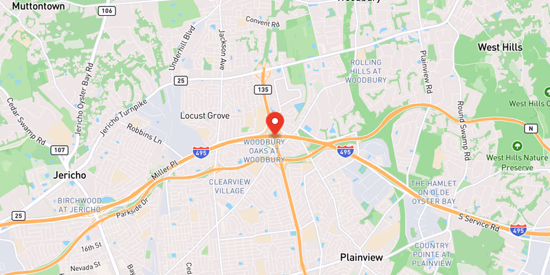
Exit 13 — Long Island Expressway / I-495 interchange (Syosset / Locust Grove): The partial-cloverleaf junction with the LIE is the highest-conflict point on the entire corridor. Ramps feed directly into and out of high-speed I-495 mainline traffic with short acceleration lanes, and the interchange handles the heaviest weaving volumes on NY 135, especially during the westbound AM peak. This is the same junction (LIE Exit 44, Syosset) where an overturned car carrier blocked lanes in May 2026.
Exit 4 — Southern State Parkway interchange (Wantagh / Levittown line): The southern major junction becomes a summer chokepoint as beach-bound and returning traffic funnels between the Southern State and NY 135 along the Jones Beach access chain. The compressed interchange geometry forces simultaneous high-speed weaving movements, and crashes here spike on warm-weather Fridays and weekends.
Exit 12 — Northern State Parkway interchange (Plainview): The Northern State junction sits only a short distance south of the LIE interchange, compressing the distance drivers have between two of Long Island’s busiest parkway/expressway merges. Drivers sorting themselves for either the Northern State or I-495 make late, high-speed lane changes — a recurring sideswipe and rear-end pattern.
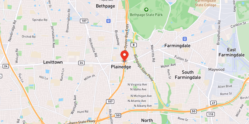
Exits 8–9 — Bethpage wide-median segment (Bethpage): Through Bethpage the northbound and southbound roadways separate around a broad, tree-covered median originally reserved for a never-built parkway extension, with the southbound lanes elevated above the northbound. The lane alignments shift as the carriageways pull apart and then come back together before Exit 9, and unfamiliar drivers misjudge the geometry, particularly at night and in poor weather.
Exit 2 — Sunrise Highway / NY 27 interchange (Seaford): Near the southern end, the split for Sunrise Highway involves separate northbound-only and southbound ramps and bridges that cross NY 27 on different alignments. The merging and diverging traffic, combined with the transition from the surface-street grid of Seaford onto the freeway, produces frequent low-speed and merge-related crashes.
Towns and Communities Along the Route
NY 135 passes through (or directly borders) the following Nassau County communities, listed south to north:
- Seaford (Nassau)
- Wantagh (Nassau)
- Massapequa (Nassau)
- Levittown (Nassau)
- Farmingdale (Nassau)
- Plainview (Nassau)
- Syosset (Nassau)
- Oyster Bay (Nassau)
The corridor also runs directly through Bethpage and Plainedge and serves Bethpage State Park — home of the Black Course that has hosted the U.S. Open, the PGA Championship, and the 2025 Ryder Cup — via the Exit 8 ramps. Each linked town profile carries its own crash-frequency data, hospital and emergency-services list, and a recent accident archive filtered to that municipality.
Recent Editorial Coverage
Recent NY 135 reporting and related corridor coverage from the Long Island Traffic data desk:
- Two-Vehicle Property Damage Crash on Route 135 to Southern State — a May 2026 collision on the Exit 4E ramp from NY 135 northbound to the Southern State Parkway
- Property-Damage Crash on Route 135 Southbound at the Southern State Ramp — an April 2026 single-vehicle crash at the same Exit 4 interchange
- Overturned Car Carrier on I-495 at Exit 44 in Syosset — a loaded car carrier rolled at the LIE interchange that forms NY 135’s northern terminus, underscoring the corridor’s commercial-truck mix
- Long Island Road Closures and Construction: The Complete 2026 Guide — the data desk’s guide to LI closures and alternates, including the Seaford-Oyster Bay Expressway
- The Southern State Parkway Problem: Why One Road Leads Long Island in Fatalities — analysis of the parallel parkway that connects to NY 135 at Exit 4
For the complete NY 135 accident archive, see /accidents/ and filter by road.
Accident Statistics
NYSDOT Motor Vehicle Crash data and New York Open Data records show that crashes on the Seaford-Oyster Bay Expressway concentrate heavily at its two major termini rather than along the open mid-section. The I-495 interchange (Exit 13) at the north and the Southern State Parkway interchange (Exit 4) at the south consistently account for a disproportionate share of reported crashes on the corridor, with the Northern State Parkway interchange (Exit 12) close behind. Across its 10.8 miles the freeway typically logs on the order of several hundred reported crashes per year, the bulk of them rear-end and sideswipe collisions tied to merge and weave conflicts at the interchanges. Because NY 135 is engineered as a 55 mph freeway, crashes here tend to be higher-severity than those on the surrounding surface roads, and the corridor’s commercial-truck access adds occasional debris, jackknife, and rollover incidents that are absent from the parallel parkways.
For the most current picture of conditions on the road right now, the Live Accident & Traffic Reports section above pulls directly from 511NY and our own ingestion pipeline.