State Parkway · Nassau & Suffolk County

Southern State Parkway Traffic & Accidents

Traffic conditions, accident reports, and safety information for the Southern State Parkway on Long Island — Nassau and Suffolk County's primary south shore corridor.

Major activity 4 accidents in the last 24 hours · as of Jun 30 View live incidents →
Tracked incidents
153
Length
30 mi
Exits
44
Speed limit
55 mph
Daily traffic
120k

Route Overview

From
Valley Stream (Nassau/Queens border)
To
Heckscher State Park (East Islip)
Also Known As
Southern State, SSP, southern-stpkwy, southern-state-pkwy, southern-state-pky

Why the Southern State Parkway Matters

Congestion & Risk

Among the highest-fatality parkways in New York State on a per-mile basis.

History

Opened in stages 1927-1949 under Robert Moses. Built to passenger-car-only standards with deliberately low bridge clearances.

About the Southern State Parkway

The Southern State Parkway is Long Island’s central south-shore artery, running roughly 30 miles from the Queens–Nassau border at Valley Stream east to Heckscher State Park in East Islip, Suffolk County. It carries an estimated 120,000 vehicles per day, making it one of the busiest parkways in New York State. For residents of Nassau’s south-shore communities — Valley Stream, Malverne, Rockville Centre, Freeport, Baldwin, Massapequa — and the south-shore Suffolk towns around Babylon and Islip, the “Southern State” is the primary commuter route to and from New York City, connecting at its western end to the Cross Island and Belt Parkway systems. It is also widely described as Long Island’s most dangerous parkway, a reputation earned over decades of high-severity crashes on a road never built for modern traffic.

Robert Moses and the parkway’s origins

The Southern State was conceived and built by Robert Moses as part of his Long Island State Park Commission program, opening in stages between 1927 and 1949. Moses envisioned a scenic leisure road carrying Nassau and city motorists to the beaches of Jones Beach Island, which he was developing simultaneously as a flagship public recreation destination. The original design — gently curving alignment, ornamental stone-faced bridges, narrow lanes, and minimal shoulders — was tuned for the unhurried pace of 1930s recreational motoring, not the 55-mph commuter and weekend-beach crush the corridor handles today.

The low-bridge legacy

The parkway’s most infamous characteristic is its low overhead clearances. Dozens of bridges date to the 1930s, and the most restrictive points carry clearances far below interstate standard. This was not an accident of engineering: Moses deliberately had the overpasses built low to keep buses — and, by extension, the lower-income and city residents who depended on them — off the parkway and away from Jones Beach. The practical result today is a high-volume road from which all commercial trucks and buses are banned, both by regulation and by the physical impossibility of clearing the bridges. Box trucks, rental moving vans, and the occasional over-height contractor’s truck still strike these overpasses; the Wantagh State Parkway interchange structures are recurring strike points, and bridge strikes routinely shut a direction for cleanup and inspection.

Route geometry

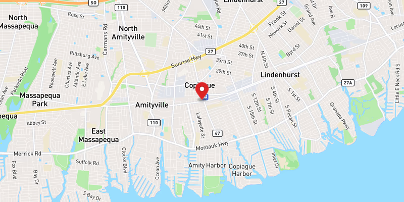
The parkway begins at the Cross Island Parkway / Belt Parkway interchange at the Queens–Nassau border in Valley Stream — its exit numbers continue the sequence from the Cross Island Parkway, which is why SSP exits start in the teens rather than at 1. From there it runs east through the dense south-shore Nassau communities of Malverne, Lakeview, Rockville Centre, Baldwin, and Freeport, crossing through Hempstead Lake State Park near Exit 18 (where the road narrows to six lanes through a wooded, tree-lined cut). It intersects the Meadowbrook State Parkway (Exit 22) and the Wantagh State Parkway — the two principal Jones Beach feeder routes — before reaching NY-110 / Broadhollow Road (Exit 32) at the Amityville/Farmingdale line. Continuing into Suffolk County through Babylon, the parkway meets the Robert Moses Causeway (Exit 40) near West Islip/Bay Shore, then transitions into the Heckscher State Parkway, which terminates at Heckscher State Park. The nearby Sagtikos State Parkway connection (Exit 41A) links north toward the Sunken Meadow Parkway.

Jurisdiction and patrol

New York State Police Troop L holds primary patrol and investigative jurisdiction over the entire Southern State Parkway, in both Nassau and Suffolk Counties. The Nassau County Police Department (NCPD) and Suffolk County Police Department (SCPD) provide traffic-control and mutual-aid support at major incidents but are not the lead investigative agency on the corridor. Troop L also mounts periodic dedicated-enforcement campaigns on the parkway in direct response to fatal-crash trends — including the 2026 “Operation: Southern Shield” detail, a multi-week initiative targeting speeding, impaired, and reckless driving.

Speed limits

The posted limit is 55 mph for the full length of the parkway. Because the lanes are an antiquated 11 feet wide (versus the modern 12-foot standard), shoulders are minimal or absent through long stretches, and the cloverleaf ramps have very short acceleration and weaving distances, real-world operating speeds during off-peak hours commonly run well above the limit. That gap between design speed and operating speed is the single biggest driver of the parkway’s elevated crash severity. Automated speed-camera enforcement has been studied for the corridor but, as of 2026, has not been deployed; enforcement remains a Troop L patrol function.

Dangerous Sections

The Southern State consistently ranks among the highest per-mile fatality parkways in New York State. The following segments are documented hot spots based on NYSDOT crash patterns, the parkway’s interchange geometry, and Long Island Traffic’s running corpus of accident reports.

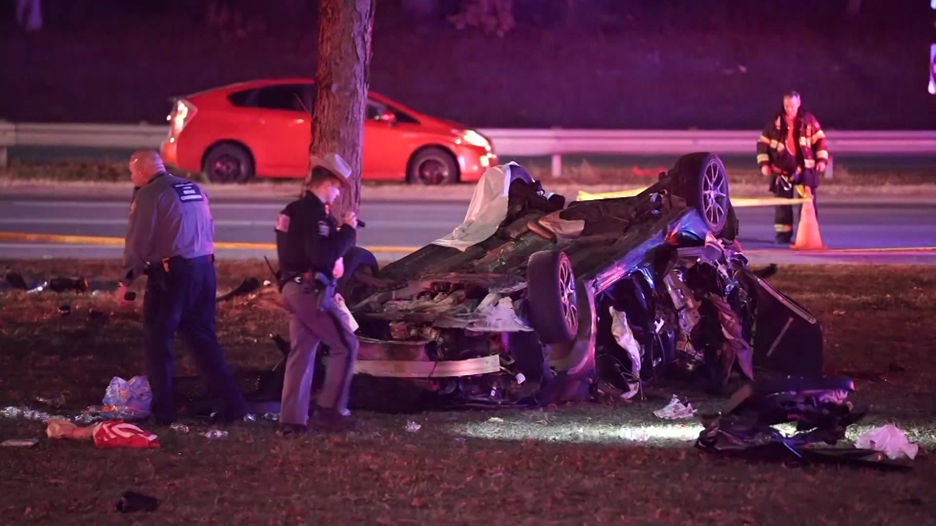
Exit 17 — Hempstead Avenue cloverleaf (Malverne): This 1920s-era cloverleaf packs four tight loop ramps into a compressed footprint, forcing drivers to weave across mainline lanes within a few hundred feet to enter or exit. The combination of short merge distances and 55-mph mainline speeds produces frequent sideswipe and rear-end crashes. The Malverne segment was the location of a March 2026 fatal wrong-way crash, in which an intoxicated driver crossed the median and triggered a five-car collision that killed an elderly couple from Westbury.

Exit 18 — Eagle Avenue / Hempstead Lake State Park (Lakeview): Just east of Exit 17 the parkway narrows to six lanes and curves through a wooded cut along Hempstead Lake State Park. There are effectively no shoulders, the tree line sits close to the travel lanes, and the older stone overpasses restrict sight distance. This stretch is over-represented in single-vehicle run-off-road and fixed-object (tree and bridge-abutment) crashes, especially at night and in wet conditions where the limited recovery room offers little margin after a loss of control.

Exit 22 — Meadowbrook State Parkway interchange (North Merrick): The Meadowbrook interchange is the busiest junction on the Southern State and a textbook weaving problem. Exits 22, 23 (Meadowbrook Road), and 24 are clustered within roughly a single mile, so drivers entering from one ramp must immediately cross lanes to reach the next — all while Jones Beach traffic floods both parkways on warm-weather weekends. Memorial Day through Labor Day, this interchange produces the corridor’s most severe backups and a sharp seasonal spike in crash frequency.

Exit 40 — Robert Moses Causeway (West Islip / Bay Shore): As the parkway crosses into Suffolk and approaches the Robert Moses Causeway split, the corridor thins and traffic that has been crawling through western Nassau suddenly opens up. Drivers conditioned to stop-and-go conditions often misjudge the speed differential as the road clears, and rear-end collisions are the dominant crash type through this transition. The causeway interchange itself adds merging conflicts from beach-bound traffic heading toward Robert Moses State Park and Fire Island.

Low-clearance overpasses and the Wantagh Parkway interchange — truck strikes: The parkway’s defining hazard is structural. Over-height vehicles — most often rental moving trucks and box trucks whose drivers ignore the posted clearance and “cars only” signage — strike the 1930s stone-faced overpasses with grim regularity. The Wantagh State Parkway interchange bridges are repeat strike points. A strike typically shears the top off the offending vehicle, scatters debris across the travel lanes, and forces a directional closure while NYSDOT inspects the bridge for structural damage before reopening.

Towns and Communities Along the Route

The Southern State Parkway passes through or borders the following Long Island communities, listed roughly west-to-east. Each town profile carries its own crash-frequency data, emergency-services list, and recent accident archive filtered to that municipality.

Recent Editorial Coverage

Recent Southern State Parkway crashes and enforcement covered by the Long Island Traffic data desk:

For the complete Southern State Parkway accident archive, see /accidents/ and filter by road. The corpus runs to several hundred SSP-related reports.

Accident Statistics

NYSDOT Motor Vehicle Crash data place the Southern State Parkway in the range of 1,500–2,000 reported crashes annually across its Nassau and Suffolk segments. Injury-crash rates per vehicle-mile traveled are elevated relative to the LIE because of the parkway’s narrower 11-foot lanes, minimal shoulders, and older alignment, which leave far less room to recover from an incipient loss of control. Single-vehicle run-off-road crashes are proportionally more common here than on the expressways — particularly at night and in wet weather along the unlit, tree-lined stretches through Hempstead Lake State Park and east into Suffolk. The western Nassau sections near Valley Stream also see elevated hit-and-run rates, attributable to proximity to the Queens border and the high volume of cross-jurisdictional traffic. Nighttime crash severity consistently outpaces daytime on the Southern State, where long unlit segments offer no ambient lighting to aid driver recovery.

These figures are qualitative ranges drawn from NYSDOT and NY Open Data crash datasets; they are not a substitute for the live picture. For conditions on the road right now, the Live Accident & Traffic Reports section above pulls directly from 511NY and our own ingestion pipeline.

Given the Southern State’s crash history, anyone injured here should understand their rights after a parkway accident.

Southern State Parkway Conditions Today — Live 250 active

Tuesday, June 30: 89 active accidents, 98 road-work zones, and 8 closures on Southern State Parkway right now — data from 511NY + police feeds, updated Jun 30, 8:32 PM.

8 high impact 173 moderate 14 low 40 EB · 41 WB work zones

Recent Southern State Parkway Incidents

Active Closures (8)

High impact Eastbound

Exit 41N → 42S: CR 57 – 5th Avenue

High impact Eastbound

Exit 18 – Eagle Avenue

All lanes closed
High impact Westbound

Exit 21 → 20S: Nassau Road – Grand Avenue

All lanes closed
High impact Westbound

Exit 30N – North Broadway

All lanes closed
High impact Eastbound

Exit 17N – Hempstead Avenue

All lanes closed · ends 2:00 PM
High impact Eastbound

Exit 14 – Fletcher Avenue EB

All lanes closed and detoured
High impact Westbound

Exit 19S – Peninsula Boulevard

All lanes closed
High impact Eastbound

Exit 19N – Peninsula Boulevard

All lanes and right shoulder closed

Active Road Work (98 zones)

Moderate impact Westbound +4 nearby

Exit 20S → 19N: Grand Avenue – Peninsula Boulevard

1 Right lane closed · ends 3:00 PM
Moderate impact Westbound +4 nearby

Exit 30N – North Broadway

1 Right lane closed · ends 3:00 AM
Moderate impact Both Directions +3 nearby

Exit 42S → 44E: 5th Avenue – Sunrise Highway

Moderate impact Both Directions +3 nearby

Exit 41A → 42S: Sagtikos State Parkway – 5th Avenue

Moderate impact Eastbound +3 nearby

Exit 17S → 18: Hempstead Avenue – Eagle Avenue

1 Right lane closed · ends 4:00 AM
Moderate impact Eastbound +3 nearby

Exit 27S → 28N: Wantagh State Parkway – Wantagh Avenue

1 Right lane closed · ends 4:00 AM
Moderate impact Eastbound +3 nearby

Exit 30N – North Broadway

1 Right lane closed · ends 3:00 PM
Moderate impact Westbound +3 nearby

Exit 15 – North Corona Avenue

· ends 3:00 PM
Moderate impact Westbound +2 nearby

Exit 28A – NY 135

2 Left lanes closed · ends 4:00 AM
Moderate impact Eastbound +2 nearby

Exit 20N → 21: Baldwin Road – Nassau Road

1 Right lane closed · ends 2:00 PM
Moderate impact Eastbound +2 nearby

Exit 15 → 17N: North Corona Avenue – Hempstead Avenue

1 Right lane closed · ends 2:00 AM
Moderate impact Westbound +2 nearby

Exit 44W → 43N: Sunrise Highway – NY 111

1 Left lane closed · ends 3:00 PM
Show 86 more work zones ↓
Moderate Both Directions

Exit 13S – Central Avenue

Moderate Westbound

Exit 13N – North Central Avenue

2 Left lanes closed · ends 2:00 PM
Moderate Eastbound

Exit 41A → 44E: Sagtikos State Parkway – Sunrise Highway

1 Right lane closed · ends 2:30 PM
Moderate Eastbound

Exit 15 → 17S: North Corona Avenue – Hempstead Avenue

1 Right lane closed · ends 3:00 PM
Moderate Eastbound

Exit 32S → 38: Nassau-Suffolk County Line – Belmont Lake State Park

1 Left lane closed · ends 2:00 PM
Moderate Westbound

Exit 40 → 32N: Robert Moses Causeway – NY 110

1 Left lane closed · ends 3:00 PM
Moderate Eastbound

Exit 20S → 21: Grand Avenue – Nassau Road

1 Right lane closed · ends 12:00 PM
Moderate Westbound

Exit 32S → 23: Nassau-Suffolk County Line – Meadowbrook Road

1 Left lane closed · ends 3:00 PM
Moderate Westbound

Exit 43A → 43N: Carleton Avenue – NY 111

1 Right lane closed · ends 3:00 PM
Moderate Both Directions

Exit 41A → 42N: Sagtikos State Parkway – CR 13

Moderate Westbound

Exit 20N → 19N: Baldwin Road – Peninsula Boulevard

1 Right lane closed · ends 2:00 PM
Moderate Eastbound

Exit 43S → 44E: NY 111 – Sunrise Highway

1 Left lane closed · ends 3:30 PM
Moderate Eastbound

Exit 42S → 43N: 5th Avenue – NY 111

1 Right lane closed · ends 3:00 PM
Moderate Westbound

Exit 26 → 23: Bellmore Road EB – Meadowbrook Road

2 Left lanes closed · ends 3:00 AM
Moderate Eastbound

Exit 28N – Wantagh Avenue

2 Right lanes closed · ends 4:00 AM
Moderate Eastbound

Exit 26 → 27N: Bellmore Road EB – Wantagh State Parkway

2 Left lanes closed · ends 4:00 AM
Moderate Westbound

Exit 27S → 24S: Wantagh State Parkway – Merrick Avenue

1 Right lane closed · ends 5:00 AM
Moderate Westbound

Exit 24N → 23: Merrick Avenue – Meadowbrook Road

1 Left lane closed · ends 3:00 PM
Moderate Westbound

Exit 18 – Eagle Avenue

1 Left lane closed
Moderate Westbound

Exit 28N – Wantagh Avenue

Moderate Westbound

Exit 28A → 28N: NY 135 – Wantagh Avenue

Moderate Westbound

Exit 23 → 13N: Meadowbrook Road – North Central Avenue

1 Left lane closed · ends 3:00 PM
Moderate Eastbound

Exit 14 → 17S: Fletcher Avenue EB – Hempstead Avenue

1 Right lane closed · ends 2:00 PM
Moderate Eastbound

Exit 23 → 32S: Meadowbrook Road – Nassau-Suffolk County Line

1 Left lane closed · ends 3:00 PM
Moderate Westbound

Exit 20S → 19S: Grand Avenue – Peninsula Boulevard

1 Right lane closed · ends 12:00 PM
Moderate Westbound

Exit 44W → 43S: Sunrise Highway – NY 111

1 Right lane closed
Moderate Eastbound

Exit 19N → 20S: Peninsula Boulevard – Grand Avenue

1 Right lane closed
Moderate Eastbound

Exit 19S → 20N: Peninsula Boulevard – Baldwin Road

1 Right lane closed · ends 3:00 PM
Moderate Eastbound

Exit 19N → 20N: Peninsula Boulevard – Baldwin Road

1 Right lane closed · ends 12:30 PM
Moderate Eastbound

Exit 42N → 44W: CR 13 – Sunrise Highway

1 Left lane closed · ends 3:00 PM
Moderate Eastbound

Exit 40 – Robert Moses Causeway

1 Right lane closed · ends 6:00 AM
Moderate Eastbound

Exit 42S → 43A: 5th Avenue – Carleton Avenue

1 Left lane closed · ends 3:00 PM
Moderate Eastbound

Exit 41A → 43S: Sagtikos State Parkway – NY 111

1 Left lane closed · ends 3:30 PM
Moderate Both Directions

Exit 41S → 46: CR 57 – Timberpoint Road

Moderate Eastbound

Exit 23 → 32N: Meadowbrook Road – NY 110

1 Left lane closed · ends 3:00 PM
Moderate Westbound

Overhead sign repair, Overnight roadwork on Southern State Parkway

Moderate Westbound

Exit 44E → 41S: Sunrise Highway – CR 57

1 Right lane closed · ends 3:00 PM
Moderate Westbound

Exit 16 – Franklin Avenue WB

1 Right lane closed · ends 5:00 AM
Moderate Both Directions

Exit 14 → 17N: Fletcher Avenue EB – Hempstead Avenue

3 Left lanes closed · ends 5:00 AM
Moderate Westbound

Exit 25S – NY 106

1 Left lane closed · ends 3:00 PM
Moderate Westbound

Exit 46 → 42S: Timberpoint Road – 5th Avenue

2 Left lanes closed · ends 2:00 PM
Moderate Westbound

Exit 24S – Merrick Avenue

1 Center lane closed
Moderate Both Directions

Exit 45W – NY 27A

1 Right lane closed
Moderate Both Directions

Bridge work on Southern State Parkway

Moderate Eastbound

Exit 40 → 41S: Robert Moses Causeway – CR 57

1 Left lane closed · ends 2:00 PM
Moderate Eastbound

Exit 27N → 28N: Wantagh State Parkway – Wantagh Avenue

Moderate Eastbound

Exit 28S → 28A: Wantagh Avenue – NY 135

2 Left lanes closed
Moderate Westbound

Exit 41N – CR 57

1 Right lane closed · ends 3:00 PM
Moderate Westbound

Exit 40 → 39N: Robert Moses Causeway – NY 231

1 Left lane closed
Moderate Westbound

Exit 39S – Sylvan Road

2 Left lanes closed · ends 1:00 AM
Moderate Westbound

Exit 27S → 23: Wantagh State Parkway – Meadowbrook Road

2 Left lanes closed · ends 4:00 AM
Moderate Westbound

Exit 37S → 23: Belmont Avenue – Meadowbrook Road

Moderate Eastbound

Exit 43N → 46: NY 111 – Timberpoint Road

2 Left lanes closed · ends 2:00 PM
Moderate Westbound

Exit 17S → 13S: Hempstead Avenue – Central Avenue

1 Left lane closed · ends 2:00 PM
Moderate Eastbound

Exit 13S → 17S: Central Avenue – Hempstead Avenue

1 Left lane closed
Moderate Eastbound

Exit 21 → 23: Nassau Road – Meadowbrook Road

1 Left lane closed
Moderate Westbound

Exit 40 → 39S: Robert Moses Causeway – Sylvan Road

1 Right lane closed · ends 3:00 PM
Moderate Westbound

Exit 17S → 15: Hempstead Avenue – North Corona Avenue

1 Left lane closed
Moderate Eastbound

Exit 39S – Sylvan Road

1 Right lane closed
Moderate Eastbound

Exit 26 → 27S: Bellmore Road EB – Wantagh State Parkway

1 Left lane closed
Moderate Westbound

Exit 17N → 15: Hempstead Avenue – North Corona Avenue

1 Left lane closed · ends 2:00 PM
Moderate Westbound

Exit 41N → 38: CR 57 – Belmont Lake State Park

2 Left lanes closed · ends 5:00 AM
Moderate Eastbound

Exit 22S → 23: Meadowbrook State Parkway – Meadowbrook Road

1 Left lane closed · ends 3:00 PM
Moderate Both Directions

Exit 41N – CR 57

Moderate Westbound

Exit 41A → 38: Sagtikos State Parkway – Belmont Lake State Park

1 Right lane closed · ends 5:00 AM
Moderate Eastbound

Exit 21 → 22S: Nassau Road – Meadowbrook State Parkway

1 Left lane closed · ends 2:00 PM
Moderate Westbound

Exit 41A – Sagtikos State Parkway

1 Right lane closed · ends 2:00 PM
Moderate Eastbound

Exit 20S → 22S: Grand Avenue – Meadowbrook State Parkway

1 Left lane closed
Moderate Eastbound

Exit 38 → 41N: Belmont Lake State Park – CR 57

1 Right lane closed · ends 5:00 AM
Moderate Both Directions

Exit 20S → 32N: Grand Avenue – NY 110

Moderate Both Directions

Exit 41A – Sagtikos State Parkway

Moderate Westbound

Exit 26 → 24S: Bellmore Road EB – Merrick Avenue

Low Both Directions

Exit 42S → 44W: 5th Avenue – Sunrise Highway

Low Both Directions

Exit 18 → 13S: Eagle Avenue – Central Avenue

Low Both Directions

Exit 20S – Grand Avenue

All lanes open · ends 4:00 AM
Low Eastbound

Exit 20S – Grand Avenue

left shoulder closed
Low Eastbound

Exit 32S → 40: Nassau-Suffolk County Line – Robert Moses Causeway

1 Left lane blocked · ends 3:00 AM
Low Both Directions

Exit 15 → 27S: North Corona Avenue – Wantagh State Parkway

All lanes blocked · ends 5:00 AM
Low Both Directions

Exit 40 – Robert Moses Causeway

right shoulder blocked · ends 3:00 PM
Low Eastbound

Exit 36 → 37S: Straight Path – Belmont Avenue

All lanes open · ends 3:00 PM
Low Both Directions

Exit 44W → 45E: Sunrise Highway – NY 27A

right shoulder blocked · ends 3:00 PM
Low Eastbound

Exit 17S – Hempstead Avenue

All lanes open · ends 3:00 AM
Low Eastbound

Exit 19N – Peninsula Boulevard

right shoulder blocked
Low Westbound

Exit 40 – Robert Moses Causeway

1 Right lane shift · ends 12:00 PM
Low Westbound

Exit 22S – Meadowbrook State Parkway

right shoulder closed
Low Westbound

Exit 20S – Grand Avenue

All lanes open · ends 5:00 AM

511 Reported Accidents (89)

Moderate impact Eastbound

Exit 32S – Nassau-Suffolk County Line

right shoulder blocked

Moderate impact Eastbound

Exit 26 – Bellmore Road EB

1 Left lane closed

Moderate impact Westbound

Exit 33 – NY 109

right shoulder blocked

Moderate impact Eastbound

Exit 21 – Nassau Road

2 Left lanes closed

Moderate impact Westbound

Exit 28A – NY 135

1 Right lane closed

Moderate impact Westbound

Exit 31 – Bethpage State Parkway

2 Right lanes closed

Moderate impact Eastbound

Exit 37N – Belmont Avenue

1 Left lane closed

Moderate impact Westbound

Exit 32S – Nassau-Suffolk County Line

right shoulder blocked

Live data from 511NY, updated Jun 30, 8:32 PM. Impact (Low/Moderate/High) reflects lane closures & closure type, not measured delay.

Latest on Southern State Parkway 153 total

Accidents by Town

Town-specific breakouts for Southern State Parkway — every town where we've tracked three or more incidents.

Accident Statistics

153 Total Reports
70 Critical
0 Fatal

Severity mix · 153 reports

70 critical 12 major 24 moderate 47 minor

Southern State Parkway Incidents by Exit

Which Southern State Parkway exits see the most reported crashes — 58 incidents across 20 tracked exits. Tap an exit for its full incident history.

Exit Incidents Fatal Reported
Exit 17S
14
Mar 2026 – Apr 2026
Exit 13
9
Sep 2025 – Apr 2026
Exit 14
6
Apr 2026
Exit 42
3
Aug 2024
Exit 25S
3
Dec 2025
Exit 29
3
Dec 2025
Exit 19
3
Apr 2026
Exit 22N
2
Nov 2025
Exit 17
2
Mar 2026
Exit 49
2
Mar 2026
Exit 40
2
Mar 2026 – Apr 2026
Exit 24
1
Mar 2024
Exit 43
1
May 2024
Exit 43A
1
Aug 2024
Exit 39S
1
Oct 2024
Exit 38
1
Oct 2024
Exit 30S
1
Jan 2025
Exit 43N
1
May 2025
Exit 15
1
Mar 2026
Exit 53
1
Mar 2026

Dangerous Sections

  • 17
  • 18
  • 22
  • 40

Exit Accident Reports

Exits with significant accident history on Southern State Parkway:

Towns Along This Route

Frequently Asked Questions

Is there traffic on the Southern State Parkway right now?

Right now there are 89 active accidents, 153 construction zones, and 8 closures reported on the Southern State Parkway. This page shows live Southern State Parkway conditions and refreshes through the day — see the live incidents above for exact locations.

What happened on the Southern State Parkway today?

In the past 24 hours, 4 accidents have been reported on the Southern State Parkway. The most recent crashes, the most dangerous exits, and live conditions are all on this page, updated through the day.

What happened on the Southern State Parkway today?

Check the Live Accident & Traffic Reports section above for the latest SSP incidents. Long Island Traffic ingests data from 511NY, NYS Police Troop L, NCPD, SCPD, the National Weather Service, and verified social media every 15 minutes; static-page coverage rebuilds every 4 hours. For the most recent 30-minute window, 511ny.org is the upstream source.

How many accidents happen on the Southern State Parkway each year?

The Southern State Parkway records on the order of 1,500–2,000 reported crashes per year across its Nassau and Suffolk segments, based on NYSDOT Motor Vehicle Crash data ranges. The parkway's narrow 11-foot lanes, minimal shoulders, tight cloverleaf interchanges, and aging 1920s–1940s design contribute to a higher-than-average crash severity rate compared with modern divided highways of similar volume. Per-mile fatality rates on the SSP are consistently cited among the highest of any New York State parkway.

What are the most dangerous sections of the Southern State Parkway?

The cluster of cloverleaf interchanges in western Nassau — Exit 17 (Hempstead Avenue, Malverne), Exit 18 (Eagle Avenue, Lakeview), and Exit 22 (Meadowbrook State Parkway, North Merrick) — accounts for a large share of crashes because of short weaving distances and 1920s-era ramp geometry. The wooded six-lane narrowing through Hempstead Lake State Park near Exit 18 has been the site of multiple fatal single-vehicle and wrong-way crashes. Eastbound near Exit 40 (Robert Moses Causeway, West Islip/Bay Shore), abrupt speed differentials produce frequent rear-end collisions as traffic thins.

Why does the Southern State Parkway have low overpasses?

The low overpasses — some as low as roughly 7 to 9 feet at the most restrictive points — are a deliberate legacy of Robert Moses' design philosophy. Moses had the parkway bridges built low to restrict it to passenger cars and exclude buses, which were the primary way lower-income and city residents could reach Long Island's beaches. Commercial trucks, buses, and over-height vehicles are prohibited for this reason. Box trucks and rental moving trucks still strike these bridges regularly, and the Wantagh State Parkway interchange overpasses are recurring strike points.

Does the Southern State Parkway allow trucks?

No. The Southern State Parkway prohibits commercial vehicles, trucks, and buses. Low bridge overpasses physically enforce the restriction, and over-height vehicles routinely shear off their roofs when drivers ignore the posted clearance signs. Commercial drivers should use Sunrise Highway (NY-27) as the parallel south-shore alternative, or the Long Island Expressway (I-495) for east-west commercial movement across the Island.

What is the speed limit on the Southern State Parkway?

The posted speed limit on the Southern State Parkway is 55 mph throughout. The parkway's narrow 11-foot lanes and tight 1920s-era interchange geometry mean operating speeds during off-peak hours frequently exceed the posted limit — a primary contributor to the parkway's elevated crash severity. NYS Police Troop L actively patrols the corridor and has run dedicated enforcement details, including the 2026 'Operation: Southern Shield' campaign targeting dangerous driving.

Who patrols the Southern State Parkway?

New York State Police Troop L has primary patrol and investigative jurisdiction for the entire Southern State Parkway across both Nassau and Suffolk Counties. NCPD (Nassau) and SCPD (Suffolk) provide traffic-control assistance during major incidents but are not the primary investigative agency on the parkway. Troop L also runs periodic targeted enforcement initiatives on the corridor in response to fatal-crash trends.

Where does the Southern State Parkway start and end?

The Southern State Parkway begins at the Cross Island Parkway / Belt Parkway interchange near the Queens–Nassau border in Valley Stream and runs roughly 30 miles east. Near Exit 40 in West Islip/Bay Shore it meets the Robert Moses Causeway, then continues as the Heckscher State Parkway to its terminus at Heckscher State Park in East Islip, Suffolk County. The Robert Moses Causeway carries traffic south from the parkway to Robert Moses State Park and Fire Island.

Is the Southern State Parkway closed today?

Full closures of the Southern State Parkway are uncommon and are almost always incident-driven — a serious crash, a vehicle fire, police activity, or flooding — affecting one direction or a single segment rather than the whole corridor. The Live Accident & Traffic Reports section above reflects the most recent 511NY status; for the live 30-minute picture, 511ny.org is the upstream source. Lane closures for overnight maintenance are also posted there.

Has there been a fatal accident on the Southern State Parkway recently?

Yes — the Southern State has a long, documented history of fatal crashes, which is why it's frequently called Long Island's most dangerous parkway. In March 2026 an intoxicated wrong-way driver near Malverne crossed the median and caused a five-car crash that killed an elderly Westbury couple and injured several others. See the Recent Editorial Coverage section below for verified reporting on recent fatal and serious crashes, and the /accidents/ archive for the full corpus filtered to this road.

Injured in a Southern State Parkway Accident?

Roads That Connect to the Southern State Parkway

The Southern State Parkway interchanges directly with these Long Island highways and parkways — a crash or closure on one routinely backs traffic onto the others. Check live conditions on a connecting corridor before you reroute.

Sources