State Parkway · Nassau & Suffolk County

Northern State Parkway Traffic & Accidents

Live Northern State Parkway accidents, closures, and traffic conditions right now — plus every exit, the most dangerous interchanges, and a complete safety guide to the 29-mile NSP from the Grand Central Parkway to Hauppauge. Updated continuously from 511NY and NYS Police feeds.

Running clear No accidents in 24h · most recent Jun 26, 6:19 AM · as of Jun 30 View live incidents →
Tracked incidents
38
Length
29 mi
Exits
25
Speed limit
55 mph
Daily traffic
100k

Route Overview

From
Grand Central Parkway (Queens–Nassau line, Lake Success)
To
Veterans Memorial Highway / NY 347 & NY 454 (Hauppauge)
Also Known As
Northern State, Northern Parkway, NSP, northern-stpkwy, northern-state-pkwy

Why the Northern State Parkway Matters

Congestion & Risk

Among Long Island's busiest north-shore commuter parkways; 1930s–1960s geometry (narrow lanes, short ramps, low stone overpasses) drives elevated crash severity per crash.

History

Construction began in 1931 under Robert Moses; the first section (Grand Central Parkway east to Willis Avenue in Roslyn Heights) opened in July 1933. The final segment east to Hauppauge opened in 1965 — the last parkway built on Long Island. Ceremonially designated 'Purple Heart Way' in 2011.

About the Northern State Parkway

The Northern State Parkway — known to Long Islanders simply as the Northern State — is the principal limited-access commuter route across the northern half of Long Island. Running roughly 28.9 miles from the Queens–Nassau County line near Lake Success east to Veterans Memorial Highway in Hauppauge, it carries an estimated 100,000 vehicles on a typical weekday. As a state parkway it permits passenger vehicles only — no trucks, buses, or commercial traffic — and its 1930s-era design of narrow lanes, short ramps, and low stone bridges gives it a distinctive character (and a distinctive crash profile) that sets it apart from the truck-carrying Long Island Expressway a few miles to the south. In 2011 the State of New York ceremonially designated the corridor Purple Heart Way in honor of combat-wounded veterans.

Construction and the Robert Moses era

The Northern State Parkway was a signature project of Robert Moses and the Long Island State Park Commission, conceived in the 1920s as a scenic companion to the Southern State Parkway and a way to connect New York City to the parks and North Shore communities of Long Island. Construction began in 1931 with a groundbreaking near the Queens–Nassau border; the first section — carrying the Grand Central Parkway eastward to Willis Avenue (Exit 28) in Roslyn Heights — opened to traffic in July 1933. Famously, the route was bent two miles out of its way around the wealthy estates of Old Westbury and East Hills, a detour locals dubbed “Objectors’ Bend,” after landowners (and a reported payment to Moses to realign around a private golf course) forced the alignment off the Wheatley Hills. The parkway was pushed east in stages through Nassau in the 1930s and again after World War II, finally reaching its current terminus in Hauppauge in 1965 — the last parkway segment ever built on Long Island.

Route geometry

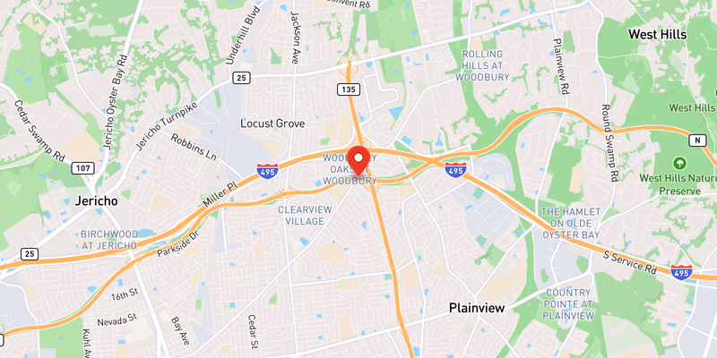
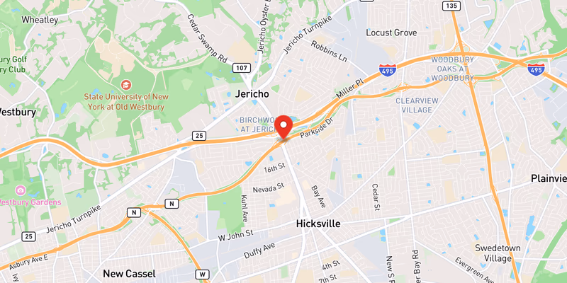
From its western end, where it continues seamlessly into New York City as the Grand Central Parkway (and on toward the RFK/Triborough Bridge), the Northern State heads east through Lake Success, New Hyde Park, and Searingtown. It runs six lanes wide through western and central Nassau, passing the interchanges at Glen Cove Road / NY 25 (Exit 31), the Meadowbrook State Parkway (Exit 31A), and the Wantagh State Parkway (Exit 33) — where it narrows to four lanes for the remainder of its length. Continuing through Jericho, Plainview, and Woodbury, it meets NY 135 (the Seaford–Oyster Bay Expressway) near Exit 36A and the Long Island Expressway at Exit 37A before crossing into Suffolk County near Round Swamp Road (Exit 39) in Melville. Through Suffolk it threads a wooded, divided four-lane corridor past NY 110 (Exit 40), Dix Hills (Exit 41), and the large Sagtikos / Sunken Meadow cloverleaf (Exits 44–45) in Commack, before its final interchange at New Highway (Exit 46) and its terminus at NY 347 / NY 454 (Veterans Memorial Highway) in Hauppauge.

Jurisdiction and patrol

New York State Police Troop L holds primary patrol and investigative jurisdiction for the entire Northern State Parkway across both Nassau and Suffolk counties; fatal and serious crashes are worked by the Troop L Bureau of Criminal Investigation (BCI). The Nassau County Police Department (NCPD) and Suffolk County Police Department (SCPD) assist with traffic control and lane closures during major incidents but are not the lead investigative agency on the parkway itself. NCPD precincts also conduct frequent enforcement stops along the Nassau stretch, where minor Vehicle and Traffic Law violations regularly turn up larger cases.

Speed limits

The posted limit is 55 mph for the full corridor. Because the road predates modern divided-highway standards — roughly 11-foot lanes, short acceleration ramps, tight curves, and minimal shoulders — actual operating speeds above the limit are a recurring contributor to crash severity, especially on the narrower four-lane Suffolk segment east of Exit 33. New York State Police enforce the limit, and work-zone moving-violation fines are doubled under VTL §1180-c.

Trucks, buses, and the low-bridge legacy

Like all New York State parkways, the Northern State prohibits commercial vehicles, trucks, and buses. The ban is not merely regulatory — it is physically enforced by the parkway’s low stone-faced overpasses, many with clearances of only about 9 to 11 feet, built in the 1930s for passenger automobiles. Box trucks, moving vans, and oversized rental trucks whose drivers ignore the posted restrictions periodically strike these bridges, forcing lane closures for structural inspection. The Long Island Expressway (I-495) was built decades later precisely to carry the truck traffic the parkways could not; commercial drivers and anyone in a tall vehicle should use the LIE or Route 25 (Jericho Turnpike) instead.

Dangerous Sections

The following segments are the Northern State’s documented hot spots, based on NYSDOT crash patterns and Long Island Traffic’s running corpus of NSP incident reports.

Exit 33 — Wantagh State Parkway interchange (Westbury): This is where the Northern State drops from six lanes to four, and the lane reduction combines with heavy merging traffic from the Wantagh State Parkway to create a chronic bottleneck and a frequent rear-end and sideswipe location. The flyover ramps and the southbound-access geometry give drivers little room to adjust, and congestion routinely stacks westbound here during the AM peak.

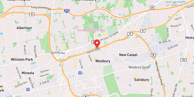
Exit 31 — Glen Cove Road / NY 25 (Carle Place): The Carle Place stretch near the Meadowbrook Parkway interchange is one of Nassau’s most heavily patrolled and highest-volume merge zones. Tight ramp spacing between Exit 31, the NY 25 access, and Exit 31A produces weaving conflicts, and the area is a frequent site of enforcement stops — including a May 2026 traffic stop that turned up a loaded handgun and switchblades.

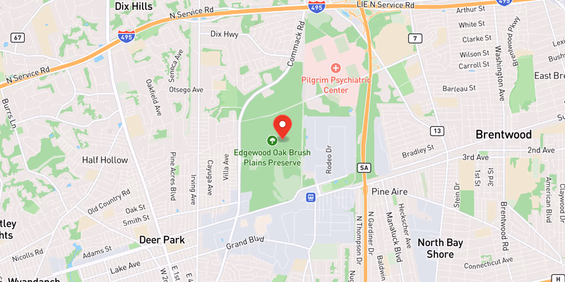
Exit 40 — NY 110 (Melville/Huntington): Exit 40 connects the parkway to the busy NY 110 (Walt Whitman Road) corridor, one of western Suffolk’s densest commercial spines. The interchange — reconstructed by NYSDOT in 2013 — sees high merge volumes and is a recurring crash location as the parkway transitions from Nassau’s wider profile into the narrower, wooded Suffolk four-lane section.

Exits 44–45 — Sagtikos / Sunken Meadow cloverleaf (Commack): This large cloverleaf ties the Northern State to the Sagtikos State Parkway (south, toward the LIE and Robert Moses Causeway) and the Sunken Meadow State Parkway (north, toward Kings Park). The looping ramps require sharp speed reductions from parkway speeds, and the multiple weaving movements through a compressed area make it one of the corridor’s top-incident segments.

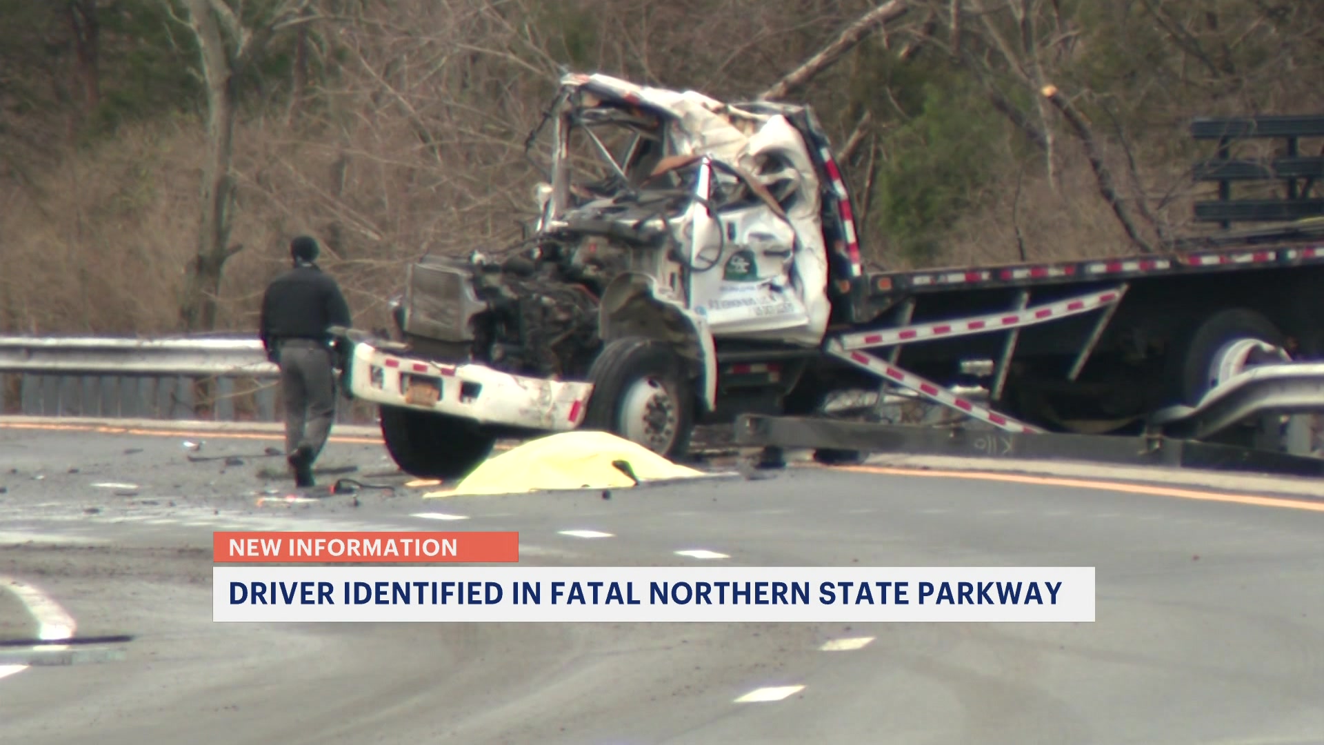
Exit 46 — New Highway (Smithtown): The easternmost interchange, on a curving divided stretch approaching the Hauppauge terminus, carries commuter traffic to and from the Hauppauge area. In late May 2026, a 29-year-old Smithtown man was killed on the westbound parkway near the New Highway overpass when his car split in half in a high-speed single-vehicle crash — a stark illustration of how unforgiving the parkway’s fixed concrete structures and tree lines are at speed.

Traffic and Commute Patterns

The Northern State Parkway is a commuter parkway first, and its congestion follows the Nassau-to-NYC workday. In the morning peak (roughly 6:30–9:30 AM), the heaviest volume runs westbound as central-Nassau and western-Suffolk drivers funnel toward the Grand Central Parkway and the city, with traffic typically stacking from the Wantagh State Parkway lane drop at Exit 33 back through Westbury and Carle Place. The evening peak (roughly 4:00–7:00 PM) reverses it: eastbound delays build from the Cross Island / Grand Central merge at the western end and again at the Exit 40 (NY 110) and Sagtikos cloverleaf (Exits 44–45) weaving zones in Suffolk.

Two patterns make the Northern State’s delays worse than its 100,000-vehicle daily count alone would suggest. First, the six-to-four-lane drop at Exit 33 is a permanent capacity bottleneck — once volume exceeds the four-lane section’s throughput, the backup propagates west regardless of incidents. Second, because the parkway bans trucks, any closure forces commercial traffic and reroutes onto the parallel Long Island Expressway and Route 25 (Jericho Turnpike), so an NSP incident routinely shows up as congestion on those corridors too.

Summer weekends add a distinct surge: beach traffic bound for Jones Beach and Robert Moses pours south onto the Meadowbrook and Wantagh parkways from the Northern State, peaking Saturday and Sunday mornings and reversing in the late afternoon. For live, current conditions on any of these connecting routes, see the Live Conditions section above and the Connecting Roads links below — a crash on the Northern State and a crash on its neighbors are rarely independent events.

Towns and Communities Along the Route

The Northern State Parkway serves (or directly borders) the following Long Island communities, listed roughly west-to-east:

Each town profile carries its own crash-frequency data, hospital and emergency-services list, and the recent accident archive filtered to that municipality.

Recent Editorial Coverage

Recent Northern State Parkway reporting from the Long Island Traffic data desk:

For the complete Northern State Parkway archive, see /accidents/ and filter by road.

Accident Statistics

NYSDOT Motor Vehicle Crash data and Long Island Traffic’s own corpus point to roughly 1,200–1,600 reported crashes per year on the Northern State Parkway. Single-vehicle run-off-road crashes and rear-end collisions make up the majority of the total — a pattern consistent with the parkway’s 1930s–1960s geometry: narrow (about 11-foot) lanes, short merge ramps, tight curves, tree-lined medians, and limited shoulders that predate current AASHTO standards for divided highways. The Nassau County segments (Exits 25–38) generally see higher crash frequency because of denser traffic and closely spaced interchanges; the Suffolk County segments (Exits 39–46), where the parkway narrows to four lanes through wooded terrain, tend to see higher crash severity from higher operating speeds and fixed roadside hazards. These figures are qualitative ranges drawn from NYSDOT / NY Open Data crash reporting and should be read as directional rather than exact annual counts.

For the most current picture of conditions on the road right now, the Live Accident & Traffic Reports section above pulls directly from 511NY and our own ingestion pipeline.

Last reviewed: May 2026.

If you were hurt in a Northern State Parkway collision, a Long Island personal injury lawyer can tell you whether you have a case.

Northern State Parkway Conditions Today — Live 180 active

Tuesday, June 30: 43 active accidents, 69 road-work zones, and 39 closures on Northern State Parkway right now — data from 511NY + police feeds, updated Jun 30, 8:32 PM.

39 high impact 99 moderate 13 low 30 EB · 30 WB work zones

Recent Northern State Parkway Incidents

Active Closures (39)

High impact Westbound

Exit 26S – New Hyde Park Road

All lanes closed
High impact Eastbound

Exit 27S – Shelter Rock Road

All lanes closed · ends 3:00 PM
High impact Eastbound

Exit 37A – Long Island Expressway

All lanes closed · ends 3:00 AM
High impact Eastbound

Exit 35S – NY 106

All lanes closed · ends 2:00 AM
High impact Eastbound

Exit 37A → 40S: Long Island Expressway – NY 110

All lanes closed · ends 5:00 AM
High impact Eastbound

Exit 36B → 40S: NY 135 – NY 110

High impact Eastbound

Exit 37A → 40S: Long Island Expressway – NY 110

All lanes closed · ends 5:00 AM
High impact Eastbound

Exit 37A → 40S: Long Island Expressway – NY 110

All lanes closed · ends 5:00 AM
High impact Westbound

Exit 29A – Long Island Expressway WB

All lanes closed
High impact Eastbound

Exit 37A → 39: Long Island Expressway – Round Swamp Road

All lanes closed · ends 5:00 AM
High impact Eastbound

Exit 37A → 39: Long Island Expressway – Round Swamp Road

All lanes closed · ends 5:00 AM
High impact Eastbound

Exit 37A → 40S: Long Island Expressway – NY 110

All lanes closed · ends 5:00 AM
High impact Eastbound

Exit 37A → 39: Long Island Expressway – Round Swamp Road

All lanes closed · ends 5:00 AM
High impact Eastbound

Exit 37A → 39: Long Island Expressway – Round Swamp Road

All lanes closed · ends 5:00 AM
High impact Eastbound

Exit 33 → 37: Wantagh State Parkway – Manetto Hill Road

All lanes closed · ends 5:00 AM
High impact Eastbound

Exit 33 → 37: Wantagh State Parkway – Manetto Hill Road

All lanes closed · ends 5:00 AM
High impact Eastbound

Exit 33 → 37: Wantagh State Parkway – Manetto Hill Road

All lanes closed · ends 5:00 AM
High impact Eastbound

Exit 33 → 37: Wantagh State Parkway – Manetto Hill Road

All lanes closed · ends 5:00 AM
High impact Eastbound

Exit 36A → 37A: NY 135 – Long Island Expressway

High impact Eastbound

Exit 33 → 37: Wantagh State Parkway – Manetto Hill Road

All lanes closed · ends 5:00 AM
High impact Eastbound

Exit 33 → 37: Wantagh State Parkway – Manetto Hill Road

All lanes closed
High impact Eastbound

Exit 33 → 37: Wantagh State Parkway – Manetto Hill Road

All lanes closed · ends 5:00 AM
High impact Eastbound

Exit 33 → 37: Wantagh State Parkway – Manetto Hill Road

All lanes closed · ends 5:00 AM
High impact Eastbound

Exit 33 → 37: Wantagh State Parkway – Manetto Hill Road

All lanes closed · ends 5:00 AM
High impact Eastbound

Exit 33 → 37: Wantagh State Parkway – Manetto Hill Road

All lanes closed · ends 5:00 AM
High impact Eastbound

Exit 33 → 36S: Wantagh State Parkway – South Oyster Bay Road

All lanes closed · ends 5:00 AM
High impact Eastbound

Exit 33 → 37: Wantagh State Parkway – Manetto Hill Road

All lanes closed
High impact Eastbound

Exit 33 → 37: Wantagh State Parkway – Manetto Hill Road

All lanes closed · ends 5:00 AM
High impact Eastbound

Exit 33 → 36N: Wantagh State Parkway – South Oyster Bay Road

All lanes closed · ends 5:00 AM
High impact Eastbound

Exit 33 → 36N: Wantagh State Parkway – South Oyster Bay Road

All lanes closed · ends 5:00 AM
High impact Eastbound

Exit 33 → 36N: Wantagh State Parkway – South Oyster Bay Road

High impact Eastbound

Exit 37 – Manetto Hill Road

All lanes closed
High impact Eastbound

Exit 33 → 36N: Wantagh State Parkway – South Oyster Bay Road

All lanes closed · ends 5:00 AM
High impact Eastbound

Exit 33 → 35N: Wantagh State Parkway – NY 106

All lanes closed · ends 5:00 AM
High impact Eastbound

Exit 33 → 35S: Wantagh State Parkway – NY 106

All lanes closed
High impact Eastbound

Exit 33 → 37: Wantagh State Parkway – Manetto Hill Road

All lanes closed · ends 5:00 AM
High impact Eastbound

Exit 33 → 36N: Wantagh State Parkway – South Oyster Bay Road

High impact Eastbound

Exit 33 → 35N: Wantagh State Parkway – NY 106

All lanes closed · ends 5:00 AM
High impact Eastbound

Exit 26N → 27S: New Hyde Park Road – Shelter Rock Road

All lanes closed

Active Road Work (69 zones)

Moderate impact Westbound +5 nearby

Exit 31A – Meadowbrook State Parkway

1 Left lane closed · ends 3:00 PM
Moderate impact Westbound +3 nearby

Exit 40S – NY 110

1 Right lane closed · ends 5:00 AM
Moderate impact Both Directions +3 nearby

Exit 31A – Meadowbrook State Parkway

1 Right lane closed · ends 6:00 AM
Moderate impact Eastbound +3 nearby

Exit 32 → 33: Post Avenue – Wantagh State Parkway

1 Left lane closed · ends 3:00 AM
Moderate impact Eastbound +2 nearby

Exit 30 → 31: I U Willets Road – Glen Cove Road

1 Right lane closed · ends 1:00 PM
Moderate impact Eastbound +2 nearby

Exit 36S → 36A: South Oyster Bay Road – NY 135

1 Right lane closed · ends 1:00 AM
Moderate impact Westbound +1 nearby

Exit 29A → 25: Long Island Expressway WB – Lakeville Road

2 Left lanes closed · ends 3:00 AM
Moderate impact Eastbound +1 nearby

Exit 33 → 40S: Wantagh State Parkway – NY 110

1 Left lane closed · ends 3:00 PM
Moderate impact Westbound +1 nearby

Exit 31A → 25: Meadowbrook State Parkway – Lakeville Road

1 Left lane closed · ends 1:30 PM
Moderate impact Westbound +1 nearby

Exit 32 – Post Avenue

1 Left lane closed · ends 3:00 PM
Moderate impact Westbound +1 nearby

Exit 40N – NY 110

1 Right lane closed · ends 3:00 PM
Moderate impact Eastbound +1 nearby

Exit 32 – Post Avenue

1 Right lane closed · ends 12:00 PM
Show 57 more work zones ↓
Moderate Eastbound

Exit 40S – NY 110

1 Left lane closed · ends 3:00 PM
Moderate Eastbound

Exit 33 – Wantagh State Parkway

1 Right lane closed · ends 2:00 AM
Moderate Westbound

Exit 36N – South Oyster Bay Road

1 Right lane closed · ends 12:00 AM
Moderate Both Directions

Exit 31A → 24: Meadowbrook State Parkway – Little Neck Parkway

1 Right lane closed · ends 6:00 AM
Moderate Westbound

Exit 32 → 31A: Post Avenue – Meadowbrook State Parkway

1 Right lane closed · ends 4:00 AM
Moderate Westbound

Exit 30 → 29: I U Willets Road – Roslyn Road

1 Left lane closed · ends 2:00 PM
Moderate Westbound

Exit 33 → 32: Wantagh State Parkway – Post Avenue

1 Right lane closed
Moderate Eastbound

Exit 31 → 32: Glen Cove Road – Post Avenue

1 Right lane closed · ends 3:00 PM
Moderate Westbound

Exit 34 – Brush Hollow Road

1 Right lane closed · ends 5:00 AM
Moderate Eastbound

Exit 26S – New Hyde Park Road

1 Right lane closed
Moderate Eastbound

Exit 25 – Lakeville Road

1 Left lane closed · ends 2:30 PM
Moderate Westbound

Exit 25 – Lakeville Road

1 Left lane closed · ends 2:00 PM
Moderate Both Directions

Exit 29 → 31: Roslyn Road – Glen Cove Road

2 Left lanes closed · ends 4:00 AM
Moderate Both Directions

Exit 30 → 31: I U Willets Road – Glen Cove Road

1 Left lane closed · ends 3:00 AM
Moderate Westbound

Exit 31 → 29A: Glen Cove Road – Long Island Expressway WB

1 Left lane closed · ends 12:00 PM
Moderate Eastbound

Exit 28S – Willis Avenue

1 Right lane closed · ends 4:00 AM
Moderate Westbound

Exit 30 → 27N: I U Willets Road – Shelter Rock Road

1 Right lane and shoulder closed
Moderate Westbound

Exit 27N – Shelter Rock Road

1 Right lane closed · ends 3:00 PM
Moderate Eastbound

Exit 28N → 29: Willis Avenue – Roslyn Road

1 Right lane closed · ends 4:00 AM
Moderate Both Directions

Bridge work on Northern State Parkway

Moderate Westbound

Exit 43 → 42S: Commack Road – Deer Park Road

1 Left lane closed
Moderate Both Directions

Exit 31A → 29: Meadowbrook State Parkway – Roslyn Road

1 Left lane closed · ends 3:00 PM
Moderate Westbound

Exit 31A → 24: Meadowbrook State Parkway – Little Neck Parkway

1 Right lane closed · ends 5:00 AM
Moderate Westbound

Exit 40S → 39: NY 110 – Round Swamp Road

1 Right lane closed · ends 2:00 AM
Moderate Eastbound

Exit 31 – Glen Cove Road

Moderate Eastbound

Exit 39 – Round Swamp Road

Moderate Eastbound

Exit 30 → 31A: I U Willets Road – Meadowbrook State Parkway

2 Left lanes closed · ends 3:00 AM
Moderate Westbound

on Northern State Parkway

2 Left lanes closed · ends 6:00 AM
Moderate Eastbound

Exit 41 → 42N: Wolf Hill Road – NY 231

1 Left lane closed · ends 2:00 PM
Moderate Eastbound

Exit 28S → 31: Willis Avenue – Glen Cove Road

1 Right lane closed · ends 3:00 PM
Moderate Westbound

Exit 43 → 38: Commack Road – Sunnyside Boulevard

1 Left lane closed · ends 5:00 AM
Moderate Eastbound

Exit 44 → 45: Sagtikos State Parkway – Sunken Meadow Parkway

1 Left lane closed · ends 3:00 PM
Moderate Eastbound

Exit 30 – I U Willets Road

Moderate Eastbound

Powells Lane

Moderate Westbound

Exit 29 – Roslyn Road

1 Left lane closed · ends 12:00 PM
Moderate Eastbound

Exit 27S → 28S: Shelter Rock Road – Willis Avenue

2 Right lanes closed
Moderate Westbound

Exit 26N → 25: New Hyde Park Road – Lakeville Road

1 Left lane closed · ends 12:00 PM
Moderate Both Directions

Exit 25 – Lakeville Road

1 Left lane closed · ends 3:00 AM
Moderate Westbound

Exit 38 → 37A: Sunnyside Boulevard – Long Island Expressway

1 Left lane closed
Moderate Eastbound

Exit 44 – Sagtikos State Parkway

1 Right lane closed · ends 2:00 PM
Moderate Westbound

Exit 37 – Manetto Hill Road

1 Right lane closed · ends 5:00 AM
Moderate Westbound

Exit 36S – South Oyster Bay Road

1 Right lane closed
Moderate Westbound

Exit 29 → 25: Roslyn Road – Lakeville Road

1 Left lane closed · ends 3:00 PM
Moderate Eastbound

Exit 36S → 36B: South Oyster Bay Road – NY 135

1 Left lane closed · ends 3:00 AM
Low Eastbound

Exit 29 → 31: Roslyn Road – Glen Cove Road

right shoulder blocked · ends 7:00 PM
Low Eastbound

Exit 25 → 31: Lakeville Road – Glen Cove Road

right shoulder blocked · ends 7:00 PM
Low Westbound

Exit 35N – NY 106

right shoulder closed · ends 3:00 PM
Low Eastbound

Exit 36S – South Oyster Bay Road

both shoulders blocked · ends 3:00 PM
Low Eastbound

Exit 28N – Willis Avenue

All lanes open · ends 4:00 AM
Low Westbound

Exit 38 – Sunnyside Boulevard

All lanes open · ends 5:00 AM
Low Westbound

Exit 39 – Round Swamp Road

All lanes open · ends 5:00 AM
Low Both Directions

Exit 35N → 32: NY 106 – Post Avenue

right shoulder closed · ends 3:00 PM
Low Both Directions

Exit 25 → 39: Lakeville Road – Round Swamp Road

Low Eastbound

Exit 36A → 39: NY 135 – Round Swamp Road

Low Eastbound

Exit 29 → 30: Roslyn Road – I U Willets Road

All lanes open
Low Eastbound

Exit 33 → 36S: Wantagh State Parkway – South Oyster Bay Road

Low Westbound

Exit 42S – Deer Park Road

right shoulder closed

511 Reported Accidents (43)

Moderate impact Eastbound

Exit 36N – South Oyster Bay Road

1 Right lane closed

Moderate impact Westbound

Exit 36A – NY 135

right shoulder blocked

Moderate impact Eastbound

Exit 32 – Post Avenue

right shoulder closed

Moderate impact Eastbound

Exit 35N – NY 106

right shoulder blocked

Moderate impact Westbound

Exit 36A – NY 135

right shoulder blocked

Moderate impact Westbound

Exit 26S – New Hyde Park Road

1 Center lane closed

Moderate impact Westbound

Exit 26S – New Hyde Park Road

right shoulder closed

Moderate impact Westbound

Exit 36B – NY 135

1 Left lane closed

Live data from 511NY, updated Jun 30, 8:32 PM. Impact (Low/Moderate/High) reflects lane closures & closure type, not measured delay.

Latest on Northern State Parkway 38 total

Accidents by Town

Town-specific breakouts for Northern State Parkway — every town where we've tracked three or more incidents.

Accident Statistics

38 Total Reports
3 Critical
0 Fatal

Severity mix · 38 reports

3 critical 5 major 9 moderate 21 minor

Northern State Parkway Incidents by Exit

Which Northern State Parkway exits see the most reported crashes — 13 incidents across 8 tracked exits. Tap an exit for its full incident history.

Exit Incidents Fatal Reported
Exit 42S
4
Apr 2026
Exit 36N
2
Mar 2026 – Apr 2026
Exit 35N
2
Apr 2026
Exit 41
1
Dec 2025
Exit 25S
1
Mar 2026
Exit 28
1
Apr 2026
Exit 42
1
Apr 2026
Exit 43
1
Apr 2026

Dangerous Sections

  • 33 — Wantagh State Parkway interchange (six-to-four-lane drop)
  • 31 — Glen Cove Road / NY 25, Carle Place
  • 40 — NY 110, Melville
  • 44–45 — Sagtikos / Sunken Meadow cloverleaf, Commack
  • 46 — New Highway, Smithtown

Towns Along This Route

Frequently Asked Questions

Is there traffic on the Northern State Parkway right now?

Right now there are 43 active accidents, 98 construction zones, and 39 closures reported on the Northern State Parkway. This page shows live Northern State Parkway conditions and refreshes through the day — see the live incidents above for exact locations.

What happened on the Northern State Parkway today?

No new Northern State Parkway accidents have been reported in the past 24 hours. This page logs every tracked Northern State Parkway incident and updates through the day — see recent incidents above for the latest.

What happened on the Northern State Parkway today?

Check the Live Conditions section above for the latest NSP incidents. Long Island Traffic ingests data from 511NY, NYS Police Troop L, NCPD, SCPD, the National Weather Service, and verified social media every 15 minutes, and this page rebuilds throughout the day so the conditions stay current. For the most recent 30-minute window, 511ny.org is the upstream source.

Does the Northern State Parkway allow trucks?

No. The Northern State Parkway bans all commercial vehicles, trucks, and buses — like every New York State parkway. The restriction is physically enforced by low stone-faced overpasses, several with clearances under 10 feet, that Robert Moses' designers built in the 1930s for passenger cars only. Trucks that ignore the signage routinely strike these bridges. Commercial traffic must use the Long Island Expressway (I-495) or Route 25 (Jericho Turnpike), which run parallel through Nassau County. The LIE was built later specifically to carry the truck traffic the parkways could not.

Why are there low bridges on the Northern State Parkway?

The parkway's overpasses date to the 1930s and were intentionally built low — many with clearances of roughly 9 to 11 feet — as part of Robert Moses' parkway aesthetic and to keep trucks and buses off the scenic road. The stone-faced bridges remain in place today and are struck periodically by box trucks, moving vans, and rental trucks whose drivers miss the 'No Commercial Vehicles' signage. A bridge strike typically closes lanes for structural inspection. Drivers of tall vehicles should route to the LIE (I-495) instead.

What is the speed limit on the Northern State Parkway?

The posted speed limit is 55 mph for the entire length of the Northern State Parkway. Because the road was engineered between the 1930s and 1960s with narrow lanes (often about 11 feet), short merge ramps, tight curves, and minimal shoulders, operating speeds above 55 mph are genuinely dangerous — a recurring factor in the corridor's serious crashes. New York State Police Troop L enforces the limit, and work-zone fines double under VTL §1180-c. The four-lane Suffolk section east of the Wantagh State Parkway (Exit 33) is especially unforgiving of high speed.

Where does the Northern State Parkway run?

The Northern State Parkway runs about 28.9 miles across the northern half of Long Island. Its western end is at the Queens–Nassau County line near Lake Success, where it continues into New York City as the Grand Central Parkway (and on to the RFK/Triborough Bridge). From there it heads east through central Nassau — Carle Place, Westbury, Plainview, and Woodbury — and into Suffolk County through Melville, Dix Hills, and Commack, ending at Veterans Memorial Highway (NY 347 / NY 454) in Hauppauge. Its numbered exits run from 25 to 46.

What are the most dangerous sections of the Northern State Parkway?

The highest-incident points are the Wantagh State Parkway interchange (Exit 33), where the parkway drops from six lanes to four; the Glen Cove Road / NY 25 area around Exit 31 in Carle Place; Exit 40 (NY 110) in Melville; the Sagtikos / Sunken Meadow cloverleaf at Exits 44–45 in Commack; and Exit 46 (New Highway) in Smithtown, where a Smithtown driver was killed in late May 2026 when his car split in half. The curved, tree-lined four-lane segments through Suffolk County produce frequent single-vehicle run-off-road crashes.

Who patrols the Northern State Parkway?

New York State Police Troop L has primary patrol and crash-investigation jurisdiction for the entire Northern State Parkway across both Nassau and Suffolk counties; serious crashes are handled by the Troop L Bureau of Criminal Investigation. The Nassau County Police Department and Suffolk County Police Department assist with traffic control at major incidents but are not the lead investigative agency on the parkway itself. To report information about a parkway crash, Troop L's Suffolk headquarters can be reached at (631) 756-3300.

How is the Northern State Parkway connected to the Long Island Expressway?

The Northern State Parkway and the Long Island Expressway run roughly parallel across Long Island and connect at several points. On the LIE, the dedicated Northern State Parkway interchange is the LIE's Exit 33 in the Woodbury/Old Westbury area; from the parkway's own numbering, it ties into the LIE at Exit 29A (Old Westbury) and Exit 37A (Woodbury). Because the parkway bans trucks, the LIE (I-495) was built later as the truck-capable east–west route and is the standard detour whenever the Northern State is closed.

What are the Grand Central, Northern State, and Wantagh Parkway interchanges?

The Northern State is the eastern continuation of the Grand Central Parkway: the two meet at the Queens–Nassau line near Lake Success with no break in the roadway. Heading east, the Meadowbrook State Parkway joins at Exit 31A and the Wantagh State Parkway at Exit 33 — both lead south toward Jones Beach. In Commack, the large cloverleaf at Exits 44–45 connects the Sagtikos State Parkway (south) and the Sunken Meadow State Parkway (north), linking the Northern State to both the South Shore and the Sunken Meadow / Kings Park area.

How many accidents happen on the Northern State Parkway each year?

The Northern State Parkway records on the order of 1,200–1,600 reported crashes per year across its Nassau and Suffolk segments, in line with NYSDOT Motor Vehicle Crash data ranges for comparable parkways. Its 1930s–1960s geometry — roughly 11-foot lanes, short ramps, and limited shoulders that predate modern AASHTO divided-highway standards — tends to produce higher injury severity per crash than newer expressways. Nassau segments see higher crash frequency from denser traffic; the four-lane Suffolk segments see higher severity from higher operating speeds.

Injured in a Northern State Parkway Accident?

Roads That Connect to the Northern State Parkway

The Northern State Parkway interchanges directly with these Long Island highways and parkways — a crash or closure on one routinely backs traffic onto the others. Check live conditions on a connecting corridor before you reroute.

Sources